Langen geodata
Langen (Lower Saxony) is a seat of a fourth-order administrative division; located in Germany in Europe/Berlin (GMT+2) time zone. With population of 1,383 people, there are 6111 cities with bigger population in this country. Compared to other cities in Germany, 77.9% of cities are located further ↓South; 87.5% of cities are located further →East and 84.5% of cities have higher elevation than Langen. Note1


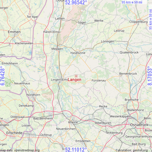
Langen GPS coordinates[2]
52° 32' 23.46" North, 7° 28' 2.64" East
| Map corner | latitude | longitude |
|---|---|---|
| Upper-left | 52.96542°, | 6.76428° |
| Center: | 52.53985°, | 7.4674° |
| Lower-right: | 52.11012°, | 8.17053° |
| Map W x H: | 95.1×95.1 km | = 59.1×59.1mi |
| max Lat: | 55.01917° ⇑22.1% North |
| Langen: | 52.53985° |
| min Lat: | ⇓77.9% South 47.40724° |
| min Long | Langen | max Long |
| 5.92978° | 7.4674° | 14.98853° |
| W 12.5%⇐ | ⇒87.5% E |
Elevation
Elevation of Langen is 36 m = 118 ft, and this is 213.1 m = 699 ft below average elevation for this country.
| Max E: |
1256 m = 4121 ft | 84.5% |
| Avg. | 249.1 m = 817 ft | |
| Langen | 36 m = 118 ft | |
Min E: |
-5 m = -16 ft | 15.5% |
See also: Germany elevation on elevation.city.
Geographical zone
Langen is located in North temperate zone (between Tropic of Cancer and the Arctic Circle). Distance of this North polar circle is 1559.3 km =968.9 mi to North.| Distance of | km | miles | from Langen |
|---|---|---|---|
| North Pole | 4165.2 | 2588.1 | to North |
| Arctic Circle | 1559.3 | 968.9 | to North |
| Tropic Cancer | 3236 | 2010.8 | to South |
| Equator | 5841.9 | 3630 | to South |


Nearby cities:
15 places around Langen: (largest is in red/bold)
• Andervenne Oberdorf
8.3 km =5.2 mi,  108°
108°
• Bawinkel
8.1 km =5 mi,  325°
325°
• Beesten
12 km =7.5 mi,  169°
169°
• Dohren
14.5 km =9 mi,  32°
32°
• Freren
7.8 km =4.8 mi,  138°
138°
• Fürstenau
14.4 km =8.9 mi,  100°
100°
• Gersten
5.9 km =3.7 mi, 34°
• Handrup
7.9 km =4.9 mi,  69°
69°
• Haselünne
15 km =9.3 mi,  4°
4°
• Lengerich
4.6 km =2.9 mi, 70°
• Lingen
10.3 km =6.4 mi,  258°
258°
• Lünne
12.6 km =7.8 mi,  192°
192°
• Messingen
8.1 km =5 mi,  180°
180°
• Thuine
4.6 km =2.9 mi, 166°
• Wettrup
10.4 km =6.5 mi,  58°
58°
Sources, notices
• [Note1] Compared only with cities in Germany existing in our database
• [Src1] Map data: © OpenStreetMap contributors (CC-BY-SA)
• [Src2] Other city data from geonames.org with taken over terms of usage.
• [Src3] Geographical zone / Annual Mean Temperature by Robert A. Rohde @ Wikipedia
