Loffenau geodata
Loffenau (Baden-Württemberg) is a seat of a fourth-order administrative division; located in Germany in Europe/Berlin (GMT+2) time zone. With population of 2,695 people, there are 4235 cities with bigger population in this country. Compared to other cities in Germany, 85.6% of cities are located further ↑North; 72.1% of cities are located further →East and 66.1% of cities have lower elevation than Loffenau. Note1
Administrative division(s):
- Level 1: Baden-Württemberg
- Level 2: Karlsruhe Region
- Level 3: Landkreis Rastatt
- Level 4: Loffenau


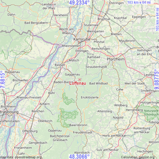
Loffenau GPS coordinates[2]
48° 46' 19.704" North, 8° 23' 4.668" East
| Map corner | latitude | longitude |
|---|---|---|
| Upper-left | 49.2334°, | 7.6815° |
| Center: | 48.77214°, | 8.38463° |
| Lower-right: | 48.3066°, | 9.08775° |
| Map W x H: | 103.1×10³ km | = 64.1×64mi |
| max Lat: | 55.01917° ⇑85.6% North |
| Loffenau: | 48.77214° |
| min Lat: | ⇓14.4% South 47.40724° |
| min Long | Loffenau | max Long |
| 5.92978° | 8.38463° | 14.98853° |
| W 27.9%⇐ | ⇒72.1% E |
Elevation
Elevation of Loffenau is 329 m = 1079 ft, and this is 79.9 m = 262 ft above average elevation for this country.
| Max E: |
1256 m = 4121 ft | 33.9% |
| Loffenau | 329 m 1079 ft | |
| Avg. | 249.1 m = 817 ft | |
Min E: |
-5 m = -16 ft | 66.1% |
See also: Germany elevation on elevation.city.
Geographical zone
Loffenau is located in North temperate zone (between Tropic of Cancer and the Arctic Circle). Distance of this North polar circle is 1978.2 km =1229.2 mi to North.| Distance of | km | miles | from Loffenau |
|---|---|---|---|
| North Pole | 4584.1 | 2848.4 | to North |
| Arctic Circle | 1978.2 | 1229.2 | to North |
| Tropic Cancer | 2817 | 1750.4 | to South |
| Equator | 5423 | 3369.7 | to South |


Nearby cities:
15 places around Loffenau: (largest is in red/bold)
• Bad Herrenalb
4.7 km =2.9 mi,  52°
52°
• Bad Wildbad
12.4 km =7.7 mi,  101°
101°
• Baden-Baden
10.7 km =6.6 mi,  263°
263°
• Bischweier
10.4 km =6.5 mi,  314°
314°
• Dobel
9 km =5.6 mi,  69°
69°
• Enzklösterle
13.4 km =8.3 mi,  151°
151°
• Forbach
10.2 km =6.3 mi,  194°
194°
• Gaggenau
4.9 km =3 mi, 309°
• Gernsbach
3.1 km =1.9 mi,  266°
266°
• Höfen an der Enz
14.9 km =9.3 mi,  77°
77°
• Kuppenheim
11.4 km =7.1 mi,  302°
302°
• Malsch
12.9 km =8 mi,  343°
343°
• Muggensturm
12.9 km =8 mi,  324°
324°
• Sinzheim
16 km =9.9 mi, 267°
• Weisenbach
5.4 km =3.4 mi,  204°
204°
Sources, notices
• [Note1] Compared only with cities in Germany existing in our database
• [Src1] Map data: © OpenStreetMap contributors (CC-BY-SA)
• [Src2] Other city data from geonames.org with taken over terms of usage.
• [Src3] Geographical zone / Annual Mean Temperature by Robert A. Rohde @ Wikipedia
