Forbach geodata
Forbach (Baden-Württemberg) is a seat of a fourth-order administrative division; located in Germany in Europe/Berlin (GMT+2) time zone. With population of 5,477 people, there are 2635 cities with bigger population in this country. Compared to other cities in Germany, 86.7% of cities are located further ↑North; 72.4% of cities are located further →East and 73.2% of cities have lower elevation than Forbach. Note1
Administrative division(s):
- Level 1: Baden-Württemberg
- Level 2: Karlsruhe Region
- Level 3: Landkreis Rastatt
- Level 4: Forbach


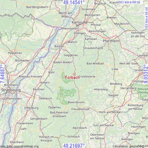
Forbach GPS coordinates[2]
48° 40' 59.988" North, 8° 21' 0" East
| Map corner | latitude | longitude |
|---|---|---|
| Upper-left | 49.14541°, | 7.64687° |
| Center: | 48.68333°, | 8.35° |
| Lower-right: | 48.21697°, | 9.05312° |
| Map W x H: | 103.2×103.2 km | = 64.1×64.1mi |
| max Lat: | 55.01917° ⇑86.7% North |
| Forbach: | 48.68333° |
| min Lat: | ⇓13.3% South 47.40724° |
| min Long | Forbach | max Long |
| 5.92978° | 8.35° | 14.98853° |
| W 27.6%⇐ | ⇒72.4% E |
Elevation
Elevation of Forbach is 384 m = 1260 ft, and this is 134.9 m = 443 ft above average elevation for this country.
| Max E: |
1256 m = 4121 ft | 26.8% |
| Forbach | 384 m 1260 ft | |
| Avg. | 249.1 m = 817 ft | |
Min E: |
-5 m = -16 ft | 73.2% |
See also: Germany elevation on elevation.city.
Geographical zone
Forbach is located in North temperate zone (between Tropic of Cancer and the Arctic Circle). Distance of this North polar circle is 1988.1 km =1235.3 mi to North.| Distance of | km | miles | from Forbach |
|---|---|---|---|
| North Pole | 4594 | 2854.6 | to North |
| Arctic Circle | 1988.1 | 1235.3 | to North |
| Tropic Cancer | 2807.2 | 1744.3 | to South |
| Equator | 5413.1 | 3363.5 | to South |


Nearby cities:
15 places around Forbach: (largest is in red/bold)
• Bad Herrenalb
14.2 km =8.8 mi,  26°
26°
• Bad Wildbad
16.5 km =10.3 mi,  62°
62°
• Baden-Baden
11.8 km =7.3 mi,  316°
316°
• Biberach
9.8 km =6.1 mi,  213°
213°
• Bühl
15.8 km =9.8 mi,  275°
275°
• Bühlertal
11.8 km =7.3 mi,  271°
271°
• Dobel
17 km =10.6 mi,  40°
40°
• Enzklösterle
9.1 km =5.7 mi,  101°
101°
• Gaggenau
13 km =8.1 mi,  354°
354°
• Gernsbach
9.7 km =6 mi,  356°
356°
• Lauf
16.3 km =10.1 mi,  256°
256°
• Loffenau
10.2 km =6.3 mi,  14°
14°
• Simmersfeld
14.3 km =8.9 mi,  121°
121°
• Sinzheim
16.3 km =10.1 mi,  304°
304°
• Weisenbach
4.9 km =3 mi,  3°
3°
Sources, notices
• [Note1] Compared only with cities in Germany existing in our database
• [Src1] Map data: © OpenStreetMap contributors (CC-BY-SA)
• [Src2] Other city data from geonames.org with taken over terms of usage.
• [Src3] Geographical zone / Annual Mean Temperature by Robert A. Rohde @ Wikipedia
