Linden geodata
Linden (Schleswig-Holstein) is a seat of a fourth-order administrative division; located in Germany in Europe/Berlin (GMT+2) time zone. With population of 859 people, there are 7670 cities with bigger population in this country. Compared to other cities in Germany, 95.7% of cities are located further ↓South; 62.7% of cities are located further →East and 90.5% of cities have higher elevation than Linden. Note1


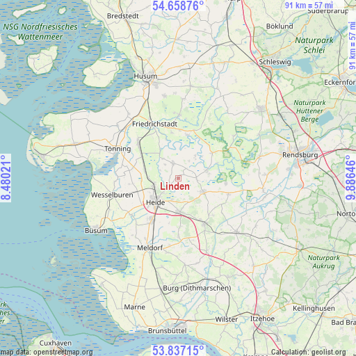
Linden GPS coordinates[2]
54° 15' 0" North, 9° 10' 59.988" East
| Map corner | latitude | longitude |
|---|---|---|
| Upper-left | 54.65876°, | 8.48021° |
| Center: | 54.25°, | 9.18333° |
| Lower-right: | 53.83715°, | 9.88646° |
| Map W x H: | 91.4×91.4 km | = 56.8×56.8mi |
| max Lat: | 55.01917° ⇑4.3% North |
| Linden: | 54.25° |
| min Lat: | ⇓95.7% South 47.40724° |
| min Long | Linden | max Long |
| 5.92978° | 9.18333° | 14.98853° |
| W 37.3%⇐ | ⇒62.7% E |
Elevation
Elevation of Linden is 20 m = 66 ft, and this is 229.1 m = 752 ft below average elevation for this country.
| Max E: |
1256 m = 4121 ft | 90.5% |
| Avg. | 249.1 m = 817 ft | |
| Linden | 20 m = 66 ft | |
Min E: |
-5 m = -16 ft | 9.5% |
See also: Germany elevation on elevation.city.
Geographical zone
Linden is located in North temperate zone (between Tropic of Cancer and the Arctic Circle). Distance of this North polar circle is 1369.1 km =850.7 mi to North.| Distance of | km | miles | from Linden |
|---|---|---|---|
| North Pole | 3975 | 2469.9 | to North |
| Arctic Circle | 1369.1 | 850.7 | to North |
| Tropic Cancer | 3426.1 | 2128.9 | to South |
| Equator | 6032 | 3748.1 | to South |


Nearby cities:
15 places around Linden: (largest is in red/bold)
• Barkenholm
1.9 km =1.2 mi,  180°
180°
• Fedderingen
4.9 km =3 mi,  318°
318°
• Gaushorn
6.4 km =4 mi,  149°
149°
• Glüsing
4.3 km =2.7 mi,  30°
30°
• Hennstedt
3.9 km =2.4 mi,  343°
343°
• Hollingstedt
5.2 km =3.2 mi, 31°
• Kleve
6.3 km =3.9 mi, 322°
• Norderheistedt
2.2 km =1.4 mi,  270°
270°
• Ostrohe
5.3 km =3.3 mi,  225°
225°
• Schalkholz
4.8 km =3 mi,  94°
94°
• Süderheistedt
2.9 km =1.8 mi, 234°
• Wallen
6.6 km =4.1 mi,  55°
55°
• Weddingstedt
6.2 km =3.9 mi,  253°
253°
• Westerborstel
6.8 km =4.2 mi,  105°
105°
• Wiemerstedt
4.7 km =2.9 mi,  293°
293°
Sources, notices
• [Note1] Compared only with cities in Germany existing in our database
• [Src1] Map data: © OpenStreetMap contributors (CC-BY-SA)
• [Src2] Other city data from geonames.org with taken over terms of usage.
• [Src3] Geographical zone / Annual Mean Temperature by Robert A. Rohde @ Wikipedia
