Lehmrade geodata
Lehmrade (Schleswig-Holstein) is a seat of a fourth-order administrative division; located in Germany in Europe/Berlin (GMT+2) time zone. With population of 460 people, there are 9506 cities with bigger population in this country. Compared to other cities in Germany, 86.9% of cities are located further ↓South; 63.2% of cities are located further ←West and 84.5% of cities have higher elevation than Lehmrade. Note1
Administrative division(s):
- Level 1: Schleswig-Holstein
- Level 3: Kreis Herzogtum Lauenburg
- Level 4: Lehmrade


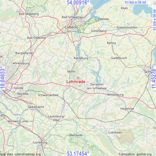
Lehmrade GPS coordinates[2]
53° 35' 38.076" North, 10° 44' 58.74" East
| Map corner | latitude | longitude |
|---|---|---|
| Upper-left | 54.00916°, | 10.04653° |
| Center: | 53.59391°, | 10.74965° |
| Lower-right: | 53.17454°, | 11.45278° |
| Map W x H: | 92.8×92.8 km | = 57.7×57.7mi |
| max Lat: | 55.01917° ⇑13.1% North |
| Lehmrade: | 53.59391° |
| min Lat: | ⇓86.9% South 47.40724° |
| min Long | Lehmrade | max Long |
| 5.92978° | 10.74965° | 14.98853° |
| W 63.2%⇐ | ⇒36.8% E |
Elevation
Elevation of Lehmrade is 36 m = 118 ft, and this is 213.1 m = 699 ft below average elevation for this country.
| Max E: |
1256 m = 4121 ft | 84.5% |
| Avg. | 249.1 m = 817 ft | |
| Lehmrade | 36 m = 118 ft | |
Min E: |
-5 m = -16 ft | 15.5% |
See also: Germany elevation on elevation.city.
Geographical zone
Lehmrade is located in North temperate zone (between Tropic of Cancer and the Arctic Circle). Distance of this North polar circle is 1442.1 km =896.1 mi to North.| Distance of | km | miles | from Lehmrade |
|---|---|---|---|
| North Pole | 4048 | 2515.3 | to North |
| Arctic Circle | 1442.1 | 896.1 | to North |
| Tropic Cancer | 3353.2 | 2083.6 | to South |
| Equator | 5959.1 | 3702.8 | to South |


Nearby cities:
15 places around Lehmrade: (largest is in red/bold)
• Alt Mölln
6.6 km =4.1 mi,  299°
299°
• Besenthal
6.8 km =4.2 mi,  189°
189°
• Breitenfelde
7.8 km =4.8 mi,  279°
279°
• Brunsmark
2.8 km =1.7 mi,  336°
336°
• Grambek
5.1 km =3.2 mi,  243°
243°
• Gudow
4.5 km =2.8 mi,  162°
162°
• Göttin
7.5 km =4.7 mi,  205°
205°
• Güster
7.8 km =4.8 mi,  218°
218°
• Hollenbek
4.7 km =2.9 mi,  93°
93°
• Klein Zecher
7.8 km =4.8 mi,  98°
98°
• Mölln
4.8 km =3 mi, 302°
• Schmilau
7.6 km =4.7 mi,  3°
3°
• Seedorf
8.2 km =5.1 mi,  69°
69°
• Sterley
5.1 km =3.2 mi,  60°
60°
• Woltersdorf
7.4 km =4.6 mi,  251°
251°
Sources, notices
• [Note1] Compared only with cities in Germany existing in our database
• [Src1] Map data: © OpenStreetMap contributors (CC-BY-SA)
• [Src2] Other city data from geonames.org with taken over terms of usage.
• [Src3] Geographical zone / Annual Mean Temperature by Robert A. Rohde @ Wikipedia
