Besenthal geodata
Besenthal (Schleswig-Holstein) is a seat of a fourth-order administrative division; located in Germany in Europe/Berlin (GMT+2) time zone. With population of 74 people, there are 10907 cities with bigger population in this country. Compared to other cities in Germany, 85.9% of cities are located further ↓South; 63% of cities are located further ←West and 87.3% of cities have higher elevation than Besenthal. Note1
Administrative division(s):
- Level 1: Schleswig-Holstein
- Level 3: Kreis Herzogtum Lauenburg
- Level 4: Besenthal


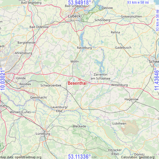
Besenthal GPS coordinates[2]
53° 31' 59.988" North, 10° 43' 59.988" East
| Map corner | latitude | longitude |
|---|---|---|
| Upper-left | 53.94918°, | 10.03021° |
| Center: | 53.53333°, | 10.73333° |
| Lower-right: | 53.11336°, | 11.43646° |
| Map W x H: | 92.9×92.9 km | = 57.7×57.7mi |
| max Lat: | 55.01917° ⇑14.1% North |
| Besenthal: | 53.53333° |
| min Lat: | ⇓85.9% South 47.40724° |
| min Long | Besenthal | max Long |
| 5.92978° | 10.73333° | 14.98853° |
| W 63%⇐ | ⇒37% E |
Elevation
Elevation of Besenthal is 29 m = 95 ft, and this is 220.1 m = 722 ft below average elevation for this country.
| Max E: |
1256 m = 4121 ft | 87.3% |
| Avg. | 249.1 m = 817 ft | |
| Besenthal | 29 m = 95 ft | |
Min E: |
-5 m = -16 ft | 12.7% |
See also: Germany elevation on elevation.city.
Geographical zone
Besenthal is located in North temperate zone (between Tropic of Cancer and the Arctic Circle). Distance of this North polar circle is 1448.8 km =900.2 mi to North.| Distance of | km | miles | from Besenthal |
|---|---|---|---|
| North Pole | 4054.7 | 2519.5 | to North |
| Arctic Circle | 1448.8 | 900.2 | to North |
| Tropic Cancer | 3346.4 | 2079.4 | to South |
| Equator | 5952.3 | 3698.6 | to South |


Nearby cities:
15 places around Besenthal: (largest is in red/bold)
• Brunsmark
9.3 km =5.8 mi,  0°
0°
• Bröthen
7.4 km =4.6 mi,  215°
215°
• Fitzen
7.2 km =4.5 mi,  233°
233°
• Grambek
5.7 km =3.5 mi,  322°
322°
• Gudow
3.5 km =2.2 mi,  44°
44°
• Göttin
2.2 km =1.4 mi,  270°
270°
• Güster
3.8 km =2.4 mi,  278°
278°
• Hollenbek
8.6 km =5.3 mi, 41°
• Hornbek
7.6 km =4.7 mi,  299°
299°
• Langenlehsten
3.6 km =2.2 mi,  172°
172°
• Lehmrade
6.8 km =4.2 mi,  9°
9°
• Roseburg
7.1 km =4.4 mi, 266°
• Siebeneichen
8 km =5 mi,  251°
251°
• Tramm
8.7 km =5.4 mi,  293°
293°
• Woltersdorf
7.4 km =4.6 mi,  306°
306°
Sources, notices
• [Note1] Compared only with cities in Germany existing in our database
• [Src1] Map data: © OpenStreetMap contributors (CC-BY-SA)
• [Src2] Other city data from geonames.org with taken over terms of usage.
• [Src3] Geographical zone / Annual Mean Temperature by Robert A. Rohde @ Wikipedia
