Leck geodata
Leck (Schleswig-Holstein) is a seat of a fourth-order administrative division; located in Germany in Europe/Berlin (GMT+2) time zone. With population of 7,593 people, there are 2044 cities with bigger population in this country. Compared to other cities in Germany, 99.5% of cities are located further ↓South; 65.7% of cities are located further →East and 96.2% of cities have higher elevation than Leck. Note1


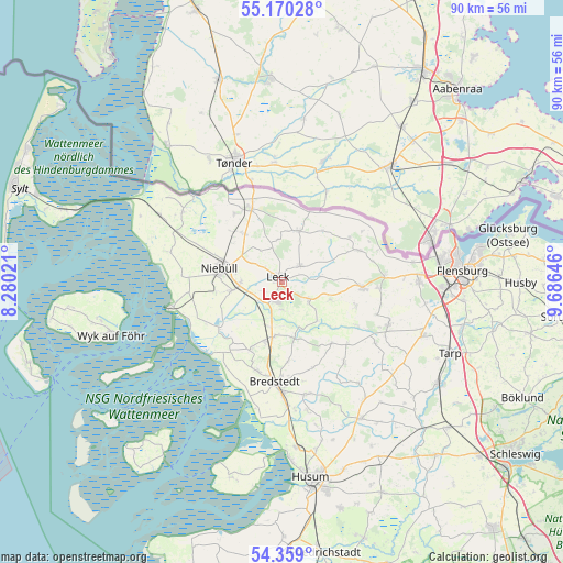
Leck GPS coordinates[2]
54° 46' 0.012" North, 8° 58' 59.988" East
| Map corner | latitude | longitude |
|---|---|---|
| Upper-left | 55.17028°, | 8.28021° |
| Center: | 54.76667°, | 8.98333° |
| Lower-right: | 54.359°, | 9.68646° |
| Map W x H: | 90.2×90.2 km | = 56×56mi |
| max Lat: | 55.01917° ⇑0.5% North |
| Leck: | 54.76667° |
| min Lat: | ⇓99.5% South 47.40724° |
| min Long | Leck | max Long |
| 5.92978° | 8.98333° | 14.98853° |
| W 34.3%⇐ | ⇒65.7% E |
Elevation
Elevation of Leck is 6 m = 20 ft, and this is 243.1 m = 798 ft below average elevation for this country.
| Max E: |
1256 m = 4121 ft | 96.2% |
| Avg. | 249.1 m = 817 ft | |
| Leck | 6 m = 20 ft | |
Min E: |
-5 m = -16 ft | 3.8% |
See also: Germany elevation on elevation.city.
Geographical zone
Leck is located in North temperate zone (between Tropic of Cancer and the Arctic Circle). Distance of this North polar circle is 1311.7 km =815.1 mi to North.| Distance of | km | miles | from Leck |
|---|---|---|---|
| North Pole | 3917.6 | 2434.3 | to North |
| Arctic Circle | 1311.7 | 815.1 | to North |
| Tropic Cancer | 3483.6 | 2164.6 | to South |
| Equator | 6089.5 | 3783.8 | to South |


Nearby cities:
15 places around Leck: (largest is in red/bold)
• Achtrup
3.9 km =2.4 mi,  47°
47°
• Bargum
7.7 km =4.8 mi,  196°
196°
• Bosbüll
9.3 km =5.8 mi,  306°
306°
• Hörup
8.1 km =5 mi,  109°
109°
• Karlum
7.5 km =4.7 mi,  351°
351°
• Klixbüll
6.9 km =4.3 mi, 306°
• Ladelund
8.6 km =5.3 mi,  16°
16°
• Lexgaard
8.1 km =5 mi,  336°
336°
• Lütjenholm
9.5 km =5.9 mi,  166°
166°
• Risum-Lindholm
7.4 km =4.6 mi,  262°
262°
• Sprakebüll
6.7 km =4.2 mi,  73°
73°
• Stadum
5.7 km =3.5 mi,  130°
130°
• Stedesand
4.7 km =2.9 mi,  228°
228°
• Tinningstedt
6.4 km =4 mi,  330°
330°
• Westre
9.3 km =5.8 mi,  0°
0°
Sources, notices
• [Note1] Compared only with cities in Germany existing in our database
• [Src1] Map data: © OpenStreetMap contributors (CC-BY-SA)
• [Src2] Other city data from geonames.org with taken over terms of usage.
• [Src3] Geographical zone / Annual Mean Temperature by Robert A. Rohde @ Wikipedia
