Langenlehsten geodata
Langenlehsten (Schleswig-Holstein) is a seat of a fourth-order administrative division; located in Germany in Europe/Berlin (GMT+2) time zone. With population of 164 people, there are 10620 cities with bigger population in this country. Compared to other cities in Germany, 85.5% of cities are located further ↓South; 63.1% of cities are located further ←West and 87.7% of cities have higher elevation than Langenlehsten. Note1
Administrative division(s):
- Level 1: Schleswig-Holstein
- Level 3: Kreis Herzogtum Lauenburg
- Level 4: Langenlehsten


Langenlehsten GPS coordinates[2]
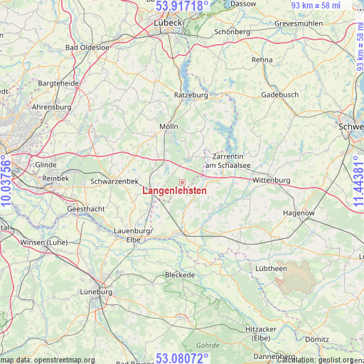
53° 30' 3.636" North, 10° 44' 26.448" East
| Map corner | latitude | longitude |
|---|---|---|
| Upper-left | 53.91718°, | 10.03756° |
| Center: | 53.50101°, | 10.74068° |
| Lower-right: | 53.08072°, | 11.44381° |
| Map W x H: | 93×93 km | = 57.8×57.8mi |
| max Lat: | 55.01917° ⇑14.5% North |
| Langenlehsten: | 53.50101° |
| min Lat: | ⇓85.5% South 47.40724° |
| min Long | Langenlehsten | max Long |
| 5.92978° | 10.74068° | 14.98853° |
| W 63.1%⇐ | ⇒36.9% E |
Elevation
Elevation of Langenlehsten is 28 m = 92 ft, and this is 221.1 m = 725 ft below average elevation for this country.
| Max E: |
1256 m = 4121 ft | 87.7% |
| Avg. | 249.1 m = 817 ft | |
| Langenlehsten | 28 m = 92 ft | |
Min E: |
-5 m = -16 ft | 12.3% |
See also: Germany elevation on elevation.city.
Geographical zone
Langenlehsten is located in North temperate zone (between Tropic of Cancer and the Arctic Circle). Distance of this North polar circle is 1452.4 km =902.5 mi to North.| Distance of | km | miles | from Langenlehsten |
|---|---|---|---|
| North Pole | 4058.3 | 2521.7 | to North |
| Arctic Circle | 1452.4 | 902.5 | to North |
| Tropic Cancer | 3342.8 | 2077.1 | to South |
| Equator | 5948.8 | 3696.4 | to South |


Nearby cities:
15 places around Langenlehsten: (largest is in red/bold)
• Besenthal
3.6 km =2.2 mi,  352°
352°
• Bröthen
5.4 km =3.4 mi,  243°
243°
• Büchen
8.5 km =5.3 mi,  254°
254°
• Fitzen
6.3 km =3.9 mi,  263°
263°
• Grambek
9 km =5.6 mi,  333°
333°
• Gresse
8 km =5 mi,  177°
177°
• Gudow
6.4 km =4 mi,  17°
17°
• Göttin
4.5 km =2.8 mi,  323°
323°
• Güster
6 km =3.7 mi,  314°
314°
• Hornbek
10.2 km =6.3 mi, 315°
• Klein Pampau
10.1 km =6.3 mi,  277°
277°
• Roseburg
8.2 km =5.1 mi,  293°
293°
• Schwanheide
8.8 km =5.5 mi,  205°
205°
• Siebeneichen
8.2 km =5.1 mi, 277°
• Woltersdorf
10.2 km =6.3 mi, 321°
Sources, notices
• [Note1] Compared only with cities in Germany existing in our database
• [Src1] Map data: © OpenStreetMap contributors (CC-BY-SA)
• [Src2] Other city data from geonames.org with taken over terms of usage.
• [Src3] Geographical zone / Annual Mean Temperature by Robert A. Rohde @ Wikipedia
