Lambsborn geodata
Lambsborn (Rheinland-Pfalz) is a seat of a fourth-order administrative division; located in Germany in Europe/Berlin (GMT+2) time zone. With population of 753 people, there are 8083 cities with bigger population in this country. Compared to other cities in Germany, 77.7% of cities are located further ↑North; 88.2% of cities are located further →East and 66.4% of cities have lower elevation than Lambsborn. Note1
Administrative division(s):
- Level 1: Rheinland-Pfalz
- Level 3: Landkreis Kaiserslautern
- Level 4: Lambsborn


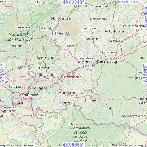
Lambsborn GPS coordinates[2]
49° 22' 0.012" North, 7° 25' 59.988" East
| Map corner | latitude | longitude |
|---|---|---|
| Upper-left | 49.82243°, | 6.73021° |
| Center: | 49.36667°, | 7.43333° |
| Lower-right: | 48.90665°, | 8.13646° |
| Map W x H: | 101.8×101.8 km | = 63.3×63.3mi |
| max Lat: | 55.01917° ⇑77.7% North |
| Lambsborn: | 49.36667° |
| min Lat: | ⇓22.3% South 47.40724° |
| min Long | Lambsborn | max Long |
| 5.92978° | 7.43333° | 14.98853° |
| W 11.8%⇐ | ⇒88.2% E |
Elevation
Elevation of Lambsborn is 331 m = 1086 ft, and this is 81.9 m = 269 ft above average elevation for this country.
| Max E: |
1256 m = 4121 ft | 33.6% |
| Lambsborn | 331 m 1086 ft | |
| Avg. | 249.1 m = 817 ft | |
Min E: |
-5 m = -16 ft | 66.4% |
See also: Germany elevation on elevation.city.
Geographical zone
Lambsborn is located in North temperate zone (between Tropic of Cancer and the Arctic Circle). Distance of this North polar circle is 1912.1 km =1188.1 mi to North.| Distance of | km | miles | from Lambsborn |
|---|---|---|---|
| North Pole | 4518 | 2807.4 | to North |
| Arctic Circle | 1912.1 | 1188.1 | to North |
| Tropic Cancer | 2883.1 | 1791.5 | to South |
| Equator | 5489.1 | 3410.8 | to South |


Nearby cities:
15 places around Lambsborn: (largest is in red/bold)
• Bechhofen
3 km =1.9 mi,  232°
232°
• Bruchmühlbach-Miesau
1.9 km =1.2 mi,  0°
0°
• Gerhardsbrunn
6.3 km =3.9 mi,  107°
107°
• Gries
6.1 km =3.8 mi,  336°
336°
• Hauptstuhl
5.2 km =3.2 mi,  44°
44°
• Hütschenhausen
6.6 km =4.1 mi,  33°
33°
• Kleinbundenbach
5.6 km =3.5 mi,  180°
180°
• Knopp-Labach
6.1 km =3.8 mi,  127°
127°
• Krähenberg
4.4 km =2.7 mi,  146°
146°
• Käshofen
3.9 km =2.4 mi,  198°
198°
• Langwieden
5.2 km =3.2 mi,  69°
69°
• Martinshöhe
3.6 km =2.2 mi,  90°
90°
• Rosenkopf
1.9 km =1.2 mi, 180°
• Schönenberg-Kübelberg
6.3 km =3.9 mi,  315°
315°
• Wiesbach
3.9 km =2.4 mi,  161°
161°
Sources, notices
• [Note1] Compared only with cities in Germany existing in our database
• [Src1] Map data: © OpenStreetMap contributors (CC-BY-SA)
• [Src2] Other city data from geonames.org with taken over terms of usage.
• [Src3] Geographical zone / Annual Mean Temperature by Robert A. Rohde @ Wikipedia
