Schönenberg-Kübelberg geodata
Schönenberg-Kübelberg (Rheinland-Pfalz) is a seat of a fourth-order administrative division; located in Germany in Europe/Berlin (GMT+2) time zone. With population of 5,957 people, there are 2472 cities with bigger population in this country. Compared to other cities in Germany, 77.1% of cities are located further ↑North; 88.9% of cities are located further →East and 55.8% of cities have lower elevation than Schönenberg-Kübelberg. Note1
Administrative division(s):
- Level 1: Rheinland-Pfalz
- Level 3: Landkreis Kusel
- Level 4: Schönenberg-Kübelberg


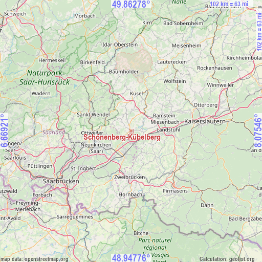
Schönenberg-Kübelberg GPS coordinates[2]
49° 24' 26.64" North, 7° 22' 20.388" East
| Map corner | latitude | longitude |
|---|---|---|
| Upper-left | 49.86278°, | 6.66921° |
| Center: | 49.4074°, | 7.37233° |
| Lower-right: | 48.94776°, | 8.07546° |
| Map W x H: | 101.7×101.7 km | = 63.2×63.2mi |
| max Lat: | 55.01917° ⇑77.1% North |
| Schönenberg-Kübelberg: | 49.4074° |
| min Lat: | ⇓22.9% South 47.40724° |
| min Long | Schönenberg-K� | max Long |
| 5.92978° | 7.37233° | 14.98853° |
| W 11.1%⇐ | ⇒88.9% E |
Elevation
Elevation of Schönenberg-Kübelberg is 264 m = 866 ft, and this is 14.9 m = 49 ft above average elevation for this country.
| Max E: |
1256 m = 4121 ft | 44.2% |
| Schönenberg-Kübelberg | 264 m 866 ft | |
| Avg. | 249.1 m = 817 ft | |
Min E: |
-5 m = -16 ft | 55.8% |
See also: Germany elevation on elevation.city.
Geographical zone
Schönenberg-Kübelberg is located in North temperate zone (between Tropic of Cancer and the Arctic Circle). Distance of this North polar circle is 1907.6 km =1185.3 mi to North.| Distance of | km | miles | from Schönenberg-Kübelberg |
|---|---|---|---|
| North Pole | 4513.5 | 2804.6 | to North |
| Arctic Circle | 1907.6 | 1185.3 | to North |
| Tropic Cancer | 2887.7 | 1794.3 | to South |
| Equator | 5493.6 | 3413.6 | to South |


Nearby cities:
15 places around Schönenberg-Kübelberg: (largest is in red/bold)
• Altenkirchen
5.4 km =3.4 mi,  316°
316°
• Bechhofen
6.7 km =4.2 mi,  162°
162°
• Bruchmühlbach-Miesau
5.2 km =3.2 mi,  121°
121°
• Brücken
2.8 km =1.7 mi,  341°
341°
• Börsborn
3.5 km =2.2 mi,  34°
34°
• Dittweiler
3.7 km =2.3 mi,  313°
313°
• Dunzweiler
4.9 km =3 mi,  281°
281°
• Frohnhofen
7.4 km =4.6 mi, 314°
• Gries
2.3 km =1.4 mi,  62°
62°
• Krottelbach
7.2 km =4.5 mi, 336°
• Lambsborn
6.3 km =3.9 mi,  135°
135°
• Nanzdietschweiler
7.3 km =4.5 mi,  49°
49°
• Ohmbach
5 km =3.1 mi, 341°
• Rosenkopf
7.8 km =4.8 mi,  145°
145°
• Waldmohr
3.9 km =2.4 mi,  226°
226°
Sources, notices
• [Note1] Compared only with cities in Germany existing in our database
• [Src1] Map data: © OpenStreetMap contributors (CC-BY-SA)
• [Src2] Other city data from geonames.org with taken over terms of usage.
• [Src3] Geographical zone / Annual Mean Temperature by Robert A. Rohde @ Wikipedia
