Kupferberg geodata
Kupferberg (Bavaria) is a populated place; located in Germany in Europe/Berlin (GMT+2) time zone. With population of 1,129 people, there are 6764 cities with bigger population in this country. Compared to other cities in Germany, 60.4% of cities are located further ↑North; 75.4% of cities are located further ←West and 85.6% of cities have lower elevation than Kupferberg. Note1
Administrative division(s):
- Level 1: Bavaria
- Level 2: Upper Franconia
- Level 3: Landkreis Kulmbach
- Level 4: Kupferberg


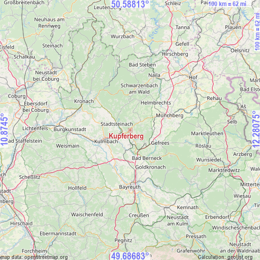
Kupferberg GPS coordinates[2]
50° 8' 22.56" North, 11° 34' 39.432" East
| Map corner | latitude | longitude |
|---|---|---|
| Upper-left | 50.58813°, | 10.8745° |
| Center: | 50.1396°, | 11.57762° |
| Lower-right: | 49.68683°, | 12.28075° |
| Map W x H: | 100.2×100.2 km | = 62.3×62.3mi |
| max Lat: | 55.01917° ⇑60.4% North |
| Kupferberg: | 50.1396° |
| min Lat: | ⇓39.6% South 47.40724° |
| min Long | Kupferberg | max Long |
| 5.92978° | 11.57762° | 14.98853° |
| W 75.4%⇐ | ⇒24.6% E |
Elevation
Elevation of Kupferberg is 474 m = 1555 ft, and this is 224.9 m = 738 ft above average elevation for this country.
| Max E: |
1256 m = 4121 ft | 14.4% |
| Kupferberg | 474 m 1555 ft | |
| Avg. | 249.1 m = 817 ft | |
Min E: |
-5 m = -16 ft | 85.6% |
See also: Germany elevation on elevation.city.
Geographical zone
Kupferberg is located in North temperate zone (between Tropic of Cancer and the Arctic Circle). Distance of this North polar circle is 1826.2 km =1134.7 mi to North.| Distance of | km | miles | from Kupferberg |
|---|---|---|---|
| North Pole | 4432.1 | 2754 | to North |
| Arctic Circle | 1826.2 | 1134.7 | to North |
| Tropic Cancer | 2969.1 | 1844.9 | to South |
| Equator | 5575 | 3464.1 | to South |


Nearby cities:
15 places around Kupferberg: (largest is in red/bold)
• Grafengehaig
7.2 km =4.5 mi,  9°
9°
• Guttenberg
2 km =1.2 mi,  332°
332°
• Himmelkron
8.3 km =5.2 mi,  168°
168°
• Ködnitz
5.4 km =3.4 mi,  215°
215°
• Ludwigschorgast
1.9 km =1.2 mi, 220°
• Marktleugast
5.5 km =3.4 mi,  47°
47°
• Marktschorgast
7.4 km =4.6 mi,  132°
132°
• Neuenmarkt
5.3 km =3.3 mi,  177°
177°
• Presseck
10 km =6.2 mi,  350°
350°
• Stadtsteinach
6 km =3.7 mi,  297°
297°
• Stammbach
8.1 km =5 mi,  85°
85°
• Steinbach
5.4 km =3.4 mi,  73°
73°
• Trebgast
8.3 km =5.2 mi,  193°
193°
• Untersteinach
4.4 km =2.7 mi,  260°
260°
• Wirsberg
4.2 km =2.6 mi,  152°
152°
Sources, notices
• [Note1] Compared only with cities in Germany existing in our database
• [Src1] Map data: © OpenStreetMap contributors (CC-BY-SA)
• [Src2] Other city data from geonames.org with taken over terms of usage.
• [Src3] Geographical zone / Annual Mean Temperature by Robert A. Rohde @ Wikipedia
