Grafengehaig geodata
Grafengehaig (Bavaria) is a populated place; located in Germany in Europe/Berlin (GMT+2) time zone. With population of 1,026 people, there are 7088 cities with bigger population in this country. Compared to other cities in Germany, 58.9% of cities are located further ↑North; 75.7% of cities are located further ←West and 94% of cities have lower elevation than Grafengehaig. Note1
Administrative division(s):
- Level 1: Bavaria
- Level 2: Upper Franconia
- Level 3: Landkreis Kulmbach
- Level 4: Grafengehaig, Markt


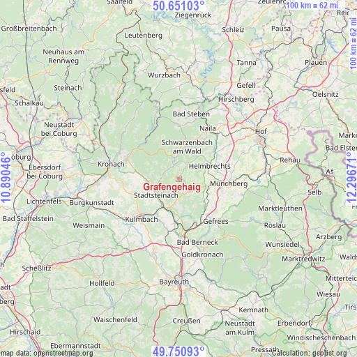
Grafengehaig GPS coordinates[2]
50° 12' 11.16" North, 11° 35' 36.888" East
| Map corner | latitude | longitude |
|---|---|---|
| Upper-left | 50.65103°, | 10.89046° |
| Center: | 50.2031°, | 11.59358° |
| Lower-right: | 49.75093°, | 12.29671° |
| Map W x H: | 100.1×100.1 km | = 62.2×62.2mi |
| max Lat: | 55.01917° ⇑58.9% North |
| Grafengehaig: | 50.2031° |
| min Lat: | ⇓41.1% South 47.40724° |
| min Long | Grafengehaig | max Long |
| 5.92978° | 11.59358° | 14.98853° |
| W 75.7%⇐ | ⇒24.3% E |
Elevation
Elevation of Grafengehaig is 575 m = 1886 ft, and this is 325.9 m = 1069 ft above average elevation for this country.
| Max E: |
1256 m = 4121 ft | 6% |
| Grafengehaig | 575 m 1886 ft | |
| Avg. | 249.1 m = 817 ft | |
Min E: |
-5 m = -16 ft | 94% |
See also: Germany elevation on elevation.city.
Geographical zone
Grafengehaig is located in North temperate zone (between Tropic of Cancer and the Arctic Circle). Distance of this North polar circle is 1819.1 km =1130.3 mi to North.| Distance of | km | miles | from Grafengehaig |
|---|---|---|---|
| North Pole | 4425 | 2749.6 | to North |
| Arctic Circle | 1819.1 | 1130.3 | to North |
| Tropic Cancer | 2976.1 | 1849.3 | to South |
| Equator | 5582.1 | 3468.6 | to South |


Nearby cities:
15 places around Grafengehaig: (largest is in red/bold)
• Guttenberg
5.7 km =3.5 mi,  201°
201°
• Helmbrechts
9.4 km =5.8 mi,  67°
67°
• Kunreuth
5.6 km =3.5 mi,  307°
307°
• Kupferberg
7.2 km =4.5 mi,  189°
189°
• Ludwigschorgast
8.9 km =5.5 mi, 195°
• Marktleugast
4.4 km =2.7 mi,  139°
139°
• Presseck
3.9 km =2.4 mi,  315°
315°
• Reichenbach
8 km =5 mi,  303°
303°
• Rugendorf
9 km =5.6 mi,  267°
267°
• Stadtsteinach
7.7 km =4.8 mi,  236°
236°
• Stammbach
9.5 km =5.9 mi,  132°
132°
• Steinbach
6.9 km =4.3 mi, 143°
• Untersteinach
9.5 km =5.9 mi,  215°
215°
• Wallenfels
11.4 km =7.1 mi, 309°
• Wirsberg
10.9 km =6.8 mi,  175°
175°
Sources, notices
• [Note1] Compared only with cities in Germany existing in our database
• [Src1] Map data: © OpenStreetMap contributors (CC-BY-SA)
• [Src2] Other city data from geonames.org with taken over terms of usage.
• [Src3] Geographical zone / Annual Mean Temperature by Robert A. Rohde @ Wikipedia
