Kulmbach geodata
Kulmbach (Bavaria) is a seat of a third-order administrative division; located in Germany in Europe/Berlin (GMT+2) time zone. With population of 27,565 people, there are 516 cities with bigger population in this country. Compared to other cities in Germany, 61.2% of cities are located further ↑North; 73.5% of cities are located further ←West and 66.2% of cities have lower elevation than Kulmbach. Note1
Administrative division(s):
- Level 1: Bavaria
- Level 2: Upper Franconia
- Level 3: Landkreis Kulmbach
- Level 4: Kulmbach


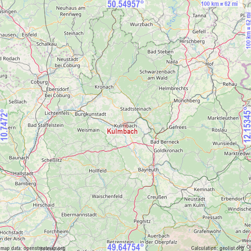
Kulmbach GPS coordinates[2]
50° 6' 2.448" North, 11° 27' 1.152" East
| Map corner | latitude | longitude |
|---|---|---|
| Upper-left | 50.54957°, | 10.7472° |
| Center: | 50.10068°, | 11.45032° |
| Lower-right: | 49.64754°, | 12.15345° |
| Map W x H: | 100.3×100.3 km | = 62.3×62.3mi |
| max Lat: | 55.01917° ⇑61.2% North |
| Kulmbach: | 50.10068° |
| min Lat: | ⇓38.8% South 47.40724° |
| min Long | Kulmbach | max Long |
| 5.92978° | 11.45032° | 14.98853° |
| W 73.5%⇐ | ⇒26.5% E |
Elevation
Elevation of Kulmbach is 330 m = 1083 ft, and this is 80.9 m = 265 ft above average elevation for this country.
| Max E: |
1256 m = 4121 ft | 33.8% |
| Kulmbach | 330 m 1083 ft | |
| Avg. | 249.1 m = 817 ft | |
Min E: |
-5 m = -16 ft | 66.2% |
See also: Germany elevation on elevation.city.
Geographical zone
Kulmbach is located in North temperate zone (between Tropic of Cancer and the Arctic Circle). Distance of this North polar circle is 1830.5 km =1137.4 mi to North.| Distance of | km | miles | from Kulmbach |
|---|---|---|---|
| North Pole | 4436.4 | 2756.7 | to North |
| Arctic Circle | 1830.5 | 1137.4 | to North |
| Tropic Cancer | 2964.8 | 1842.2 | to South |
| Equator | 5570.7 | 3461.5 | to South |


Nearby cities:
15 places around Kulmbach: (largest is in red/bold)
• Eckersdorf
8.9 km =5.5 mi,  205°
205°
• Guttenberg
10.2 km =6.3 mi,  53°
53°
• Kasendorf
10 km =6.2 mi,  224°
224°
• Kupferberg
10.1 km =6.3 mi,  64°
64°
• Ködnitz
5.9 km =3.7 mi,  90°
90°
• Ludwigschorgast
8.3 km =5.2 mi,  69°
69°
• Mainleus
5.3 km =3.3 mi,  269°
269°
• Neudrossenfeld
10 km =6.2 mi,  159°
159°
• Neuenmarkt
9.3 km =5.8 mi,  95°
95°
• Rugendorf
11.1 km =6.9 mi,  6°
6°
• Stadtsteinach
8 km =5 mi,  28°
28°
• Thurnau
9.3 km =5.8 mi, 205°
• Trebgast
8.1 km =5 mi,  118°
118°
• Untersteinach
6 km =3.7 mi, 52°
• Wirsberg
11.1 km =6.9 mi, 87°
Sources, notices
• [Note1] Compared only with cities in Germany existing in our database
• [Src1] Map data: © OpenStreetMap contributors (CC-BY-SA)
• [Src2] Other city data from geonames.org with taken over terms of usage.
• [Src3] Geographical zone / Annual Mean Temperature by Robert A. Rohde @ Wikipedia
