Thurnau geodata
Thurnau (Bavaria) is a populated place; located in Germany in Europe/Berlin (GMT+2) time zone. With population of 4,502 people, there are 3038 cities with bigger population in this country. Compared to other cities in Germany, 63.1% of cities are located further ↑North; 72.6% of cities are located further ←West and 70.4% of cities have lower elevation than Thurnau. Note1
Administrative division(s):
- Level 1: Bavaria
- Level 2: Upper Franconia
- Level 3: Landkreis Kulmbach
- Level 4: Thurnau, Markt


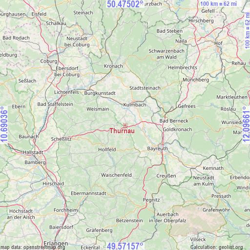
Thurnau GPS coordinates[2]
50° 1' 31.512" North, 11° 23' 36.528" East
| Map corner | latitude | longitude |
|---|---|---|
| Upper-left | 50.47502°, | 10.69036° |
| Center: | 50.02542°, | 11.39348° |
| Lower-right: | 49.57157°, | 12.09661° |
| Map W x H: | 100.5×100.5 km | = 62.4×62.4mi |
| max Lat: | 55.01917° ⇑63.1% North |
| Thurnau: | 50.02542° |
| min Lat: | ⇓36.9% South 47.40724° |
| min Long | Thurnau | max Long |
| 5.92978° | 11.39348° | 14.98853° |
| W 72.6%⇐ | ⇒27.4% E |
Elevation
Elevation of Thurnau is 361 m = 1184 ft, and this is 111.9 m = 367 ft above average elevation for this country.
| Max E: |
1256 m = 4121 ft | 29.6% |
| Thurnau | 361 m 1184 ft | |
| Avg. | 249.1 m = 817 ft | |
Min E: |
-5 m = -16 ft | 70.4% |
See also: Germany elevation on elevation.city.
Geographical zone
Thurnau is located in North temperate zone (between Tropic of Cancer and the Arctic Circle). Distance of this North polar circle is 1838.9 km =1142.6 mi to North.| Distance of | km | miles | from Thurnau |
|---|---|---|---|
| North Pole | 4444.8 | 2761.9 | to North |
| Arctic Circle | 1838.9 | 1142.6 | to North |
| Tropic Cancer | 2956.4 | 1837 | to South |
| Equator | 5562.3 | 3456.3 | to South |


Nearby cities:
15 places around Thurnau: (largest is in red/bold)
• Eckersdorf
0.4 km =0.2 mi,  26°
26°
• Eckersdorf
12.5 km =7.8 mi,  143°
143°
• Harsdorf
12.4 km =7.7 mi,  85°
85°
• Heinersreuth
11.9 km =7.4 mi,  123°
123°
• Hollfeld
12.2 km =7.6 mi,  216°
216°
• Kasendorf
3.2 km =2 mi,  292°
292°
• Kulmbach
9.3 km =5.8 mi, 25°
• Ködnitz
13 km =8.1 mi,  50°
50°
• Mainleus
8.4 km =5.2 mi,  351°
351°
• Mistelgau
13.6 km =8.5 mi,  157°
157°
• Neudrossenfeld
7.7 km =4.8 mi,  97°
97°
• Stadelhofen
14.2 km =8.8 mi,  259°
259°
• Trebgast
12.1 km =7.5 mi,  67°
67°
• Weismain
12.8 km =8 mi,  301°
301°
• Wonsees
8.6 km =5.3 mi,  230°
230°
Sources, notices
• [Note1] Compared only with cities in Germany existing in our database
• [Src1] Map data: © OpenStreetMap contributors (CC-BY-SA)
• [Src2] Other city data from geonames.org with taken over terms of usage.
• [Src3] Geographical zone / Annual Mean Temperature by Robert A. Rohde @ Wikipedia
