Krusenhagen geodata
Krusenhagen (Mecklenburg-Vorpommern) is a populated place; located in Germany in Europe/Berlin (GMT+2) time zone. With population of 529 people, there are 9201 cities with bigger population in this country. Compared to other cities in Germany, 91.9% of cities are located further ↓South; 74.8% of cities are located further ←West and 91.6% of cities have higher elevation than Krusenhagen. Note1
Administrative division(s):
- Level 1: Mecklenburg-Vorpommern
- Level 3: Nordwestmecklenburg
- Level 4: Krusenhagen


Krusenhagen GPS coordinates[2]
53° 56' 39.876" North, 11° 32' 1.896" East
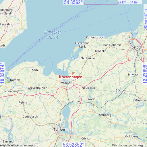
| Map corner | latitude | longitude |
|---|---|---|
| Upper-left | 54.3562°, | 10.83074° |
| Center: | 53.94441°, | 11.53386° |
| Lower-right: | 53.52852°, | 12.23699° |
| Map W x H: | 92×92 km | = 57.2×57.2mi |
| max Lat: | 55.01917° ⇑8.1% North |
| Krusenhagen: | 53.94441° |
| min Lat: | ⇓91.9% South 47.40724° |
| min Long | Krusenhagen | max Long |
| 5.92978° | 11.53386° | 14.98853° |
| W 74.8%⇐ | ⇒25.2% E |
Elevation
Elevation of Krusenhagen is 17 m = 56 ft, and this is 232.1 m = 761 ft below average elevation for this country.
| Max E: |
1256 m = 4121 ft | 91.6% |
| Avg. | 249.1 m = 817 ft | |
| Krusenhagen | 17 m = 56 ft | |
Min E: |
-5 m = -16 ft | 8.4% |
See also: Germany elevation on elevation.city.
Geographical zone
Krusenhagen is located in North temperate zone (between Tropic of Cancer and the Arctic Circle). Distance of this North polar circle is 1403.1 km =871.8 mi to North.| Distance of | km | miles | from Krusenhagen |
|---|---|---|---|
| North Pole | 4009 | 2491.1 | to North |
| Arctic Circle | 1403.1 | 871.8 | to North |
| Tropic Cancer | 3392.1 | 2107.8 | to South |
| Equator | 5998.1 | 3727 | to South |


Nearby cities:
15 places around Krusenhagen: (largest is in red/bold)
• Alt Bukow
7.6 km =4.7 mi,  38°
38°
• Benz
5 km =3.1 mi,  137°
137°
• Blowatz
5 km =3.1 mi,  359°
359°
• Boiensdorf
8.3 km =5.2 mi,  12°
12°
• Güstow
7.7 km =4.8 mi, 10°
• Hornstorf
3.8 km =2.4 mi,  181°
181°
• Lübow
10.2 km =6.3 mi, 183°
• Mecklenburg
12.2 km =7.6 mi,  202°
202°
• Neubukow
13.3 km =8.3 mi, 43°
• Neukloster
13.2 km =8.2 mi,  131°
131°
• Sellin
8.2 km =5.1 mi, 143°
• Weitendorf
12.9 km =8 mi,  245°
245°
• Wismar
7.8 km =4.8 mi,  222°
222°
• Zierow
10.5 km =6.5 mi,  258°
258°
• Zurow
10.4 km =6.5 mi,  149°
149°
Sources, notices
• [Note1] Compared only with cities in Germany existing in our database
• [Src1] Map data: © OpenStreetMap contributors (CC-BY-SA)
• [Src2] Other city data from geonames.org with taken over terms of usage.
• [Src3] Geographical zone / Annual Mean Temperature by Robert A. Rohde @ Wikipedia
