Neubukow geodata
Neubukow (Mecklenburg-Vorpommern) is a populated place; located in Germany in Europe/Berlin (GMT+2) time zone. With population of 4,276 people, there are 3146 cities with bigger population in this country. Compared to other cities in Germany, 93.1% of cities are located further ↓South; 76.8% of cities are located further ←West and 90.1% of cities have higher elevation than Neubukow. Note1
Administrative division(s):
- Level 1: Mecklenburg-Vorpommern
- Level 3: Landkreis Rostock
- Level 4: Neubukow


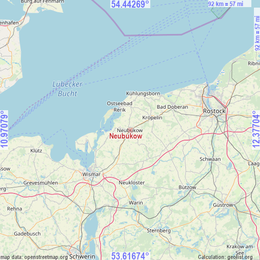
Neubukow GPS coordinates[2]
54° 1' 54.372" North, 11° 40' 26.076" East
| Map corner | latitude | longitude |
|---|---|---|
| Upper-left | 54.44269°, | 10.97079° |
| Center: | 54.03177°, | 11.67391° |
| Lower-right: | 53.61674°, | 12.37704° |
| Map W x H: | 91.8×91.8 km | = 57×57mi |
| max Lat: | 55.01917° ⇑6.9% North |
| Neubukow: | 54.03177° |
| min Lat: | ⇓93.1% South 47.40724° |
| min Long | Neubukow | max Long |
| 5.92978° | 11.67391° | 14.98853° |
| W 76.8%⇐ | ⇒23.2% E |
Elevation
Elevation of Neubukow is 21 m = 69 ft, and this is 228.1 m = 748 ft below average elevation for this country.
| Max E: |
1256 m = 4121 ft | 90.1% |
| Avg. | 249.1 m = 817 ft | |
| Neubukow | 21 m = 69 ft | |
Min E: |
-5 m = -16 ft | 9.9% |
See also: Germany elevation on elevation.city.
Geographical zone
Neubukow is located in North temperate zone (between Tropic of Cancer and the Arctic Circle). Distance of this North polar circle is 1393.4 km =865.8 mi to North.| Distance of | km | miles | from Neubukow |
|---|---|---|---|
| North Pole | 3999.3 | 2485 | to North |
| Arctic Circle | 1393.4 | 865.8 | to North |
| Tropic Cancer | 3401.9 | 2113.8 | to South |
| Equator | 6007.8 | 3733.1 | to South |


Nearby cities:
15 places around Neubukow: (largest is in red/bold)
• Alt Bukow
5.8 km =3.6 mi,  228°
228°
• Bastorf
10.5 km =6.5 mi,  8°
8°
• Biendorf
5.1 km =3.2 mi,  20°
20°
• Blowatz
10.3 km =6.4 mi,  242°
242°
• Boiensdorf
7.5 km =4.7 mi,  257°
257°
• Glasin
13.9 km =8.6 mi,  162°
162°
• Güstow
8.1 km =5 mi,  254°
254°
• Jennewitz
10.2 km =6.3 mi,  47°
47°
• Krusenhagen
13.3 km =8.3 mi,  223°
223°
• Kröpelin
8.9 km =5.5 mi,  61°
61°
• Ostseebad Kühlungsborn
14.3 km =8.9 mi, 23°
• Reddelich
13.2 km =8.2 mi, 61°
• Retschow
13.4 km =8.3 mi,  83°
83°
• Steffenshagen
12.6 km =7.8 mi, 49°
• Wittenbeck
12.5 km =7.8 mi,  36°
36°
Sources, notices
• [Note1] Compared only with cities in Germany existing in our database
• [Src1] Map data: © OpenStreetMap contributors (CC-BY-SA)
• [Src2] Other city data from geonames.org with taken over terms of usage.
• [Src3] Geographical zone / Annual Mean Temperature by Robert A. Rohde @ Wikipedia
