Wismar geodata
Wismar (Mecklenburg-Vorpommern) is a seat of a third-order administrative division; located in Germany in Europe/Berlin (GMT+2) time zone. With population of 45,255 people, there are 264 cities with bigger population in this country. Compared to other cities in Germany, 91.1% of cities are located further ↓South; 73.5% of cities are located further ←West and 98.6% of cities have higher elevation than Wismar. Note1
Administrative division(s):
- Level 1: Mecklenburg-Vorpommern
- Level 3: Nordwestmecklenburg
- Level 4: Wismar, Hansestadt


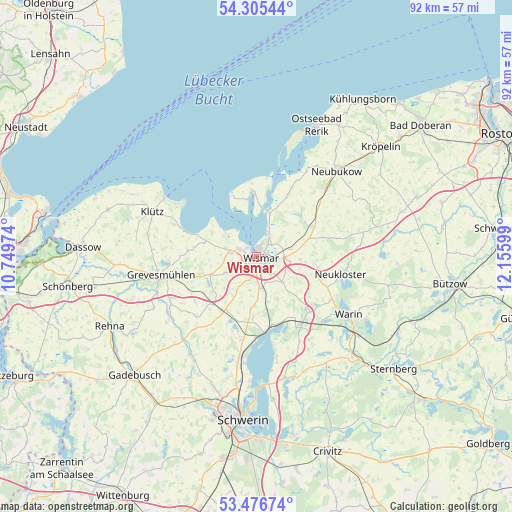
Wismar GPS coordinates[2]
53° 53' 35.304" North, 11° 27' 10.296" East
| Map corner | latitude | longitude |
|---|---|---|
| Upper-left | 54.30544°, | 10.74974° |
| Center: | 53.89314°, | 11.45286° |
| Lower-right: | 53.47674°, | 12.15599° |
| Map W x H: | 92.1×92.1 km | = 57.2×57.2mi |
| max Lat: | 55.01917° ⇑8.9% North |
| Wismar: | 53.89314° |
| min Lat: | ⇓91.1% South 47.40724° |
| min Long | Wismar | max Long |
| 5.92978° | 11.45286° | 14.98853° |
| W 73.5%⇐ | ⇒26.5% E |
Elevation
Elevation of Wismar is 1 m = 3 ft, and this is 248.1 m = 814 ft below average elevation for this country.
| Max E: |
1256 m = 4121 ft | 98.6% |
| Avg. | 249.1 m = 817 ft | |
| Wismar | 1 m = 3 ft | |
Min E: |
-5 m = -16 ft | 1.4% |
See also: Wismar elevation on elevation.city.
Geographical zone
Wismar is located in North temperate zone (between Tropic of Cancer and the Arctic Circle). Distance of this North polar circle is 1408.8 km =875.4 mi to North.| Distance of | km | miles | from Wismar |
|---|---|---|---|
| North Pole | 4014.7 | 2494.6 | to North |
| Arctic Circle | 1408.8 | 875.4 | to North |
| Tropic Cancer | 3386.4 | 2104.2 | to South |
| Equator | 5992.4 | 3723.5 | to South |


Nearby cities:
15 places around Wismar: (largest is in red/bold)
• Barnekow
6 km =3.7 mi,  240°
240°
• Beidendorf
8.4 km =5.2 mi,  210°
210°
• Benz
8.9 km =5.5 mi,  77°
77°
• Bobitz
11.6 km =7.2 mi, 211°
• Gramkow
9.4 km =5.8 mi,  289°
289°
• Groß Krankow
11.6 km =7.2 mi,  221°
221°
• Groß Stieten
8.9 km =5.5 mi,  181°
181°
• Hornstorf
5.5 km =3.4 mi,  70°
70°
• Krusenhagen
7.8 km =4.8 mi,  42°
42°
• Lübow
6.5 km =4 mi,  133°
133°
• Mecklenburg
5.7 km =3.5 mi,  173°
173°
• Sellin
10.2 km =6.3 mi,  95°
95°
• Weitendorf
6.5 km =4 mi,  272°
272°
• Zierow
6.2 km =3.9 mi,  305°
305°
• Zurow
11.1 km =6.9 mi,  106°
106°
Sources, notices
• [Note1] Compared only with cities in Germany existing in our database
• [Src1] Map data: © OpenStreetMap contributors (CC-BY-SA)
• [Src2] Other city data from geonames.org with taken over terms of usage.
• [Src3] Geographical zone / Annual Mean Temperature by Robert A. Rohde @ Wikipedia
