Krummbek geodata
Krummbek (Schleswig-Holstein) is a seat of a fourth-order administrative division; located in Germany in Europe/Berlin (GMT+2) time zone. With population of 320 people, there are 9983 cities with bigger population in this country. Compared to other cities in Germany, 97.2% of cities are located further ↓South; 57.1% of cities are located further ←West and 92% of cities have higher elevation than Krummbek. Note1


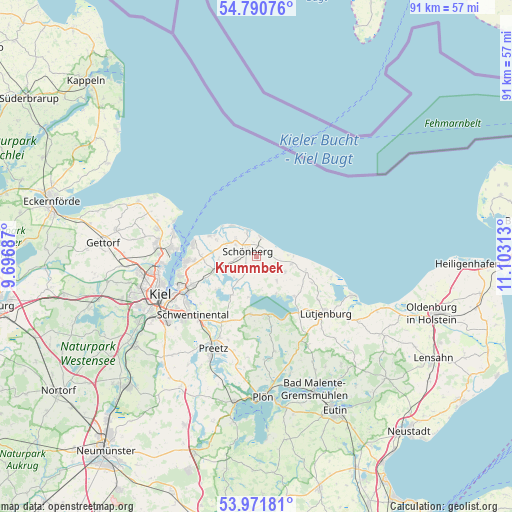
Krummbek GPS coordinates[2]
54° 22' 59.988" North, 10° 24' 0" East
| Map corner | latitude | longitude |
|---|---|---|
| Upper-left | 54.79076°, | 9.69687° |
| Center: | 54.38333°, | 10.4° |
| Lower-right: | 53.97181°, | 11.10313° |
| Map W x H: | 91.1×91.1 km | = 56.6×56.6mi |
| max Lat: | 55.01917° ⇑2.8% North |
| Krummbek: | 54.38333° |
| min Lat: | ⇓97.2% South 47.40724° |
| min Long | Krummbek | max Long |
| 5.92978° | 10.4° | 14.98853° |
| W 57.1%⇐ | ⇒42.9% E |
Elevation
Elevation of Krummbek is 16 m = 52 ft, and this is 233.1 m = 765 ft below average elevation for this country.
| Max E: |
1256 m = 4121 ft | 92% |
| Avg. | 249.1 m = 817 ft | |
| Krummbek | 16 m = 52 ft | |
Min E: |
-5 m = -16 ft | 8% |
See also: Germany elevation on elevation.city.
Geographical zone
Krummbek is located in North temperate zone (between Tropic of Cancer and the Arctic Circle). Distance of this North polar circle is 1354.3 km =841.5 mi to North.| Distance of | km | miles | from Krummbek |
|---|---|---|---|
| North Pole | 3960.2 | 2460.8 | to North |
| Arctic Circle | 1354.3 | 841.5 | to North |
| Tropic Cancer | 3440.9 | 2138.1 | to South |
| Equator | 6046.9 | 3757.4 | to South |


Nearby cities:
15 places around Krummbek: (largest is in red/bold)
• Barsbek
5.7 km =3.5 mi,  288°
288°
• Bendfeld
2.1 km =1.3 mi,  149°
149°
• Fahren
5.7 km =3.5 mi,  229°
229°
• Fargau-Pratjau
5.7 km =3.5 mi,  169°
169°
• Fiefbergen
3.2 km =2 mi,  270°
270°
• Hohenfelde
6.7 km =4.2 mi,  105°
105°
• Höhndorf
2.8 km =1.7 mi, 229°
• Krokau
3.7 km =2.3 mi,  299°
299°
• Köhn
4.9 km =3 mi,  138°
138°
• Passade
5.7 km =3.5 mi,  251°
251°
• Prasdorf
6.5 km =4 mi, 270°
• Schwartbuck
5.8 km =3.6 mi,  119°
119°
• Stakendorf
1.6 km =1 mi,  68°
68°
• Stoltenberg
4.9 km =3 mi,  221°
221°
• Wisch
4.8 km =3 mi,  309°
309°
Sources, notices
• [Note1] Compared only with cities in Germany existing in our database
• [Src1] Map data: © OpenStreetMap contributors (CC-BY-SA)
• [Src2] Other city data from geonames.org with taken over terms of usage.
• [Src3] Geographical zone / Annual Mean Temperature by Robert A. Rohde @ Wikipedia
