Hohenfelde geodata
Hohenfelde (Schleswig-Holstein) is a seat of a fourth-order administrative division; located in Germany in Europe/Berlin (GMT+2) time zone. With population of 1,104 people, there are 6835 cities with bigger population in this country. Compared to other cities in Germany, 97% of cities are located further ↓South; 58.9% of cities are located further ←West and 90.9% of cities have higher elevation than Hohenfelde. Note1


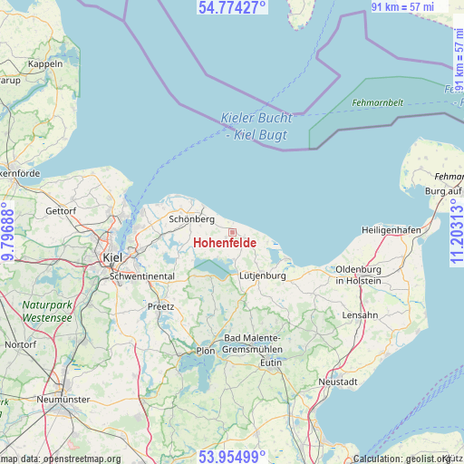
Hohenfelde GPS coordinates[2]
54° 22' 0.012" North, 10° 30' 0" East
| Map corner | latitude | longitude |
|---|---|---|
| Upper-left | 54.77427°, | 9.79688° |
| Center: | 54.36667°, | 10.5° |
| Lower-right: | 53.95499°, | 11.20313° |
| Map W x H: | 91.1×91.1 km | = 56.6×56.6mi |
| max Lat: | 55.01917° ⇑3% North |
| Hohenfelde: | 54.36667° |
| min Lat: | ⇓97% South 47.40724° |
| min Long | Hohenfelde | max Long |
| 5.92978° | 10.5° | 14.98853° |
| W 58.9%⇐ | ⇒41.1% E |
Elevation
Elevation of Hohenfelde is 19 m = 62 ft, and this is 230.1 m = 755 ft below average elevation for this country.
| Max E: |
1256 m = 4121 ft | 90.9% |
| Avg. | 249.1 m = 817 ft | |
| Hohenfelde | 19 m = 62 ft | |
Min E: |
-5 m = -16 ft | 9.1% |
See also: Germany elevation on elevation.city.
Geographical zone
Hohenfelde is located in North temperate zone (between Tropic of Cancer and the Arctic Circle). Distance of this North polar circle is 1356.2 km =842.7 mi to North.| Distance of | km | miles | from Hohenfelde |
|---|---|---|---|
| North Pole | 3962.1 | 2461.9 | to North |
| Arctic Circle | 1356.2 | 842.7 | to North |
| Tropic Cancer | 3439.1 | 2137 | to South |
| Equator | 6045 | 3756.2 | to South |


Nearby cities:
15 places around Hohenfelde: (largest is in red/bold)
• Behrensdorf
7 km =4.3 mi,  104°
104°
• Bendfeld
5.4 km =3.4 mi,  270°
270°
• Fargau-Pratjau
6.6 km =4.1 mi,  235°
235°
• Giekau
5.7 km =3.5 mi,  169°
169°
• Höhndorf
8.6 km =5.3 mi, 270°
• Klamp
7.7 km =4.8 mi,  163°
163°
• Krummbek
6.7 km =4.2 mi,  285°
285°
• Köhn
3.7 km =2.3 mi, 240°
• Lammershagen
9.8 km =6.1 mi,  199°
199°
• Panker
5.7 km =3.5 mi,  130°
130°
• Schwartbuck
1.7 km =1.1 mi,  233°
233°
• Selent
9.9 km =6.2 mi,  208°
208°
• Stakendorf
5.5 km =3.4 mi,  296°
296°
• Stoltenberg
9.9 km =6.2 mi,  259°
259°
• Tröndel
3.9 km =2.4 mi, 163°
Sources, notices
• [Note1] Compared only with cities in Germany existing in our database
• [Src1] Map data: © OpenStreetMap contributors (CC-BY-SA)
• [Src2] Other city data from geonames.org with taken over terms of usage.
• [Src3] Geographical zone / Annual Mean Temperature by Robert A. Rohde @ Wikipedia
