Kropp geodata
Kropp (Schleswig-Holstein) is a seat of a fourth-order administrative division; located in Germany in Europe/Berlin (GMT+2) time zone. With population of 6,320 people, there are 2357 cities with bigger population in this country. Compared to other cities in Germany, 97.5% of cities are located further ↓South; 57.6% of cities are located further →East and 92.3% of cities have higher elevation than Kropp. Note1
Administrative division(s):
- Level 1: Schleswig-Holstein
- Level 3: Kreis Schleswig-Flensburg
- Level 4: Kropp


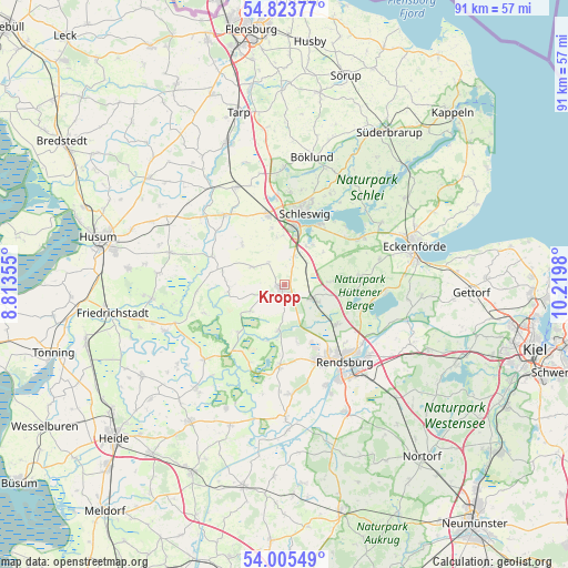
Kropp GPS coordinates[2]
54° 25' 0.012" North, 9° 31' 0.012" East
| Map corner | latitude | longitude |
|---|---|---|
| Upper-left | 54.82377°, | 8.81355° |
| Center: | 54.41667°, | 9.51667° |
| Lower-right: | 54.00549°, | 10.2198° |
| Map W x H: | 91×91 km | = 56.5×56.5mi |
| max Lat: | 55.01917° ⇑2.5% North |
| Kropp: | 54.41667° |
| min Lat: | ⇓97.5% South 47.40724° |
| min Long | Kropp | max Long |
| 5.92978° | 9.51667° | 14.98853° |
| W 42.4%⇐ | ⇒57.6% E |
Elevation
Elevation of Kropp is 15 m = 49 ft, and this is 234.1 m = 768 ft below average elevation for this country.
| Max E: |
1256 m = 4121 ft | 92.3% |
| Avg. | 249.1 m = 817 ft | |
| Kropp | 15 m = 49 ft | |
Min E: |
-5 m = -16 ft | 7.7% |
See also: Germany elevation on elevation.city.
Geographical zone
Kropp is located in North temperate zone (between Tropic of Cancer and the Arctic Circle). Distance of this North polar circle is 1350.6 km =839.2 mi to North.| Distance of | km | miles | from Kropp |
|---|---|---|---|
| North Pole | 3956.5 | 2458.5 | to North |
| Arctic Circle | 1350.6 | 839.2 | to North |
| Tropic Cancer | 3444.6 | 2140.4 | to South |
| Equator | 6050.6 | 3759.7 | to South |


Nearby cities:
15 places around Kropp: (largest is in red/bold)
• Alt Bennebek
6.5 km =4 mi,  235°
235°
• Brekendorf
7.6 km =4.7 mi,  86°
86°
• Busdorf
8.6 km =5.3 mi,  14°
14°
• Börm
8.8 km =5.5 mi,  257°
257°
• Dannewerk
7.5 km =4.7 mi,  351°
351°
• Geltorf
8.5 km =5.3 mi,  49°
49°
• Groß Rheide
6 km =3.7 mi,  297°
297°
• Jagel
4.6 km =2.9 mi,  16°
16°
• Klein Bennebek
4.7 km =2.9 mi,  246°
246°
• Klein Rheide
4.3 km =2.7 mi,  329°
329°
• Lohe-Föhrden
9.3 km =5.8 mi,  173°
173°
• Lottorf
4.9 km =3 mi,  41°
41°
• Owschlag
5.5 km =3.4 mi,  117°
117°
• Selk
6.4 km =4 mi,  30°
30°
• Tetenhusen
7.5 km =4.7 mi,  188°
188°
Sources, notices
• [Note1] Compared only with cities in Germany existing in our database
• [Src1] Map data: © OpenStreetMap contributors (CC-BY-SA)
• [Src2] Other city data from geonames.org with taken over terms of usage.
• [Src3] Geographical zone / Annual Mean Temperature by Robert A. Rohde @ Wikipedia
