Kranichfeld geodata
Kranichfeld (Thuringia) is a populated place; located in Germany in Europe/Berlin (GMT+2) time zone. With population of 3,779 people, there are 3419 cities with bigger population in this country. Compared to other cities in Germany, 55.3% of cities are located further ↓South; 70% of cities are located further ←West and 62.5% of cities have lower elevation than Kranichfeld. Note1


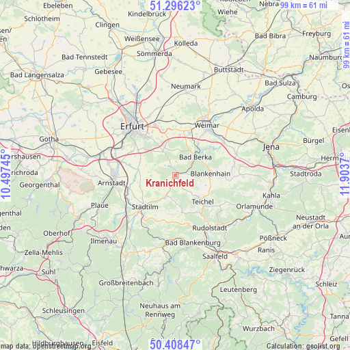
Kranichfeld GPS coordinates[2]
50° 51' 16.056" North, 11° 12' 2.052" East
| Map corner | latitude | longitude |
|---|---|---|
| Upper-left | 51.29623°, | 10.49745° |
| Center: | 50.85446°, | 11.20057° |
| Lower-right: | 50.40847°, | 11.9037° |
| Map W x H: | 98.7×98.7 km | = 61.3×61.3mi |
| max Lat: | 55.01917° ⇑44.7% North |
| Kranichfeld: | 50.85446° |
| min Lat: | ⇓55.3% South 47.40724° |
| min Long | Kranichfeld | max Long |
| 5.92978° | 11.20057° | 14.98853° |
| W 70%⇐ | ⇒30% E |
Elevation
Elevation of Kranichfeld is 305 m = 1001 ft, and this is 55.9 m = 183 ft above average elevation for this country.
| Max E: |
1256 m = 4121 ft | 37.5% |
| Kranichfeld | 305 m 1001 ft | |
| Avg. | 249.1 m = 817 ft | |
Min E: |
-5 m = -16 ft | 62.5% |
See also: Germany elevation on elevation.city.
Geographical zone
Kranichfeld is located in North temperate zone (between Tropic of Cancer and the Arctic Circle). Distance of this North polar circle is 1746.7 km =1085.3 mi to North.| Distance of | km | miles | from Kranichfeld |
|---|---|---|---|
| North Pole | 4352.6 | 2704.6 | to North |
| Arctic Circle | 1746.7 | 1085.3 | to North |
| Tropic Cancer | 3048.6 | 1894.3 | to South |
| Equator | 5654.5 | 3513.5 | to South |


Nearby cities:
15 places around Kranichfeld: (largest is in red/bold)
• Bad Berka
7.6 km =4.7 mi,  48°
48°
• Barchfeld
3.2 km =2 mi,  207°
207°
• Blankenhain
10.1 km =6.3 mi,  86°
86°
• Bösleben-Wüllersleben
9.7 km =6 mi,  255°
255°
• Elleben
8.3 km =5.2 mi,  279°
279°
• Hetschburg
9.5 km =5.9 mi, 47°
• Hohenfelden
3.9 km =2.4 mi,  313°
313°
• Klettbach
7.8 km =4.8 mi,  332°
332°
• Nauendorf
4.7 km =2.9 mi,  342°
342°
• Osthausen-Wülfershausen
8.2 km =5.1 mi,  266°
266°
• Rittersdorf
4.8 km =3 mi,  151°
151°
• Schwarza
8.7 km =5.4 mi, 90°
• Tonndorf
3.8 km =2.4 mi,  3°
3°
• Troistedt
9.4 km =5.8 mi,  21°
21°
• Witzleben
7.2 km =4.5 mi,  234°
234°
Sources, notices
• [Note1] Compared only with cities in Germany existing in our database
• [Src1] Map data: © OpenStreetMap contributors (CC-BY-SA)
• [Src2] Other city data from geonames.org with taken over terms of usage.
• [Src3] Geographical zone / Annual Mean Temperature by Robert A. Rohde @ Wikipedia
