Hetschburg geodata
Hetschburg (Thuringia) is a seat of a fourth-order administrative division; located in Germany in Europe/Berlin (GMT+2) time zone. With population of 257 people, there are 10228 cities with bigger population in this country. Compared to other cities in Germany, 56.4% of cities are located further ↓South; 71.3% of cities are located further ←West and 55.4% of cities have lower elevation than Hetschburg. Note1


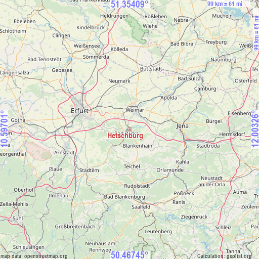
Hetschburg GPS coordinates[2]
50° 54' 46.368" North, 11° 18' 0.468" East
| Map corner | latitude | longitude |
|---|---|---|
| Upper-left | 51.35409°, | 10.59701° |
| Center: | 50.91288°, | 11.30013° |
| Lower-right: | 50.46745°, | 12.00326° |
| Map W x H: | 98.6×98.6 km | = 61.3×61.3mi |
| max Lat: | 55.01917° ⇑43.6% North |
| Hetschburg: | 50.91288° |
| min Lat: | ⇓56.4% South 47.40724° |
| min Long | Hetschburg | max Long |
| 5.92978° | 11.30013° | 14.98853° |
| W 71.3%⇐ | ⇒28.7% E |
Elevation
Elevation of Hetschburg is 261 m = 856 ft, and this is 11.9 m = 39 ft above average elevation for this country.
| Max E: |
1256 m = 4121 ft | 44.6% |
| Hetschburg | 261 m 856 ft | |
| Avg. | 249.1 m = 817 ft | |
Min E: |
-5 m = -16 ft | 55.4% |
See also: Germany elevation on elevation.city.
Geographical zone
Hetschburg is located in North temperate zone (between Tropic of Cancer and the Arctic Circle). Distance of this North polar circle is 1740.2 km =1081.3 mi to North.| Distance of | km | miles | from Hetschburg |
|---|---|---|---|
| North Pole | 4346.1 | 2700.5 | to North |
| Arctic Circle | 1740.2 | 1081.3 | to North |
| Tropic Cancer | 3055.1 | 1898.4 | to South |
| Equator | 5661 | 3517.6 | to South |


Nearby cities:
15 places around Hetschburg: (largest is in red/bold)
• Bad Berka
1.9 km =1.2 mi,  220°
220°
• Bechstedtstraß
8.1 km =5 mi,  300°
300°
• Blankenhain
6.6 km =4.1 mi,  152°
152°
• Buchfart
2.4 km =1.5 mi,  68°
68°
• Isseroda
7.4 km =4.6 mi,  310°
310°
• Kiliansroda
5 km =3.1 mi,  87°
87°
• Mechelroda
5.5 km =3.4 mi, 91°
• Mellingen
7.4 km =4.6 mi,  64°
64°
• Nohra
6.1 km =3.8 mi,  332°
332°
• Oettern
4.2 km =2.6 mi,  75°
75°
• Schwarza
6.8 km =4.2 mi,  165°
165°
• Tonndorf
7.3 km =4.5 mi,  248°
248°
• Troistedt
4.2 km =2.6 mi, 302°
• Vollersroda
3.4 km =2.1 mi,  39°
39°
• Weimar
7.8 km =4.8 mi,  15°
15°
Sources, notices
• [Note1] Compared only with cities in Germany existing in our database
• [Src1] Map data: © OpenStreetMap contributors (CC-BY-SA)
• [Src2] Other city data from geonames.org with taken over terms of usage.
• [Src3] Geographical zone / Annual Mean Temperature by Robert A. Rohde @ Wikipedia
