Kranenburg geodata
Kranenburg (Lower Saxony) is a seat of a fourth-order administrative division; located in Germany in Europe/Berlin (GMT+2) time zone. With population of 796 people, there are 7917 cities with bigger population in this country. Compared to other cities in Germany, 87.1% of cities are located further ↓South; 62.3% of cities are located further →East and 98.1% of cities have higher elevation than Kranenburg. Note1


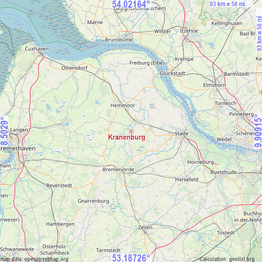
Kranenburg GPS coordinates[2]
53° 36' 23.436" North, 9° 12' 21.672" East
| Map corner | latitude | longitude |
|---|---|---|
| Upper-left | 54.02164°, | 8.5029° |
| Center: | 53.60651°, | 9.20602° |
| Lower-right: | 53.18726°, | 9.90915° |
| Map W x H: | 92.8×92.8 km | = 57.7×57.7mi |
| max Lat: | 55.01917° ⇑12.9% North |
| Kranenburg: | 53.60651° |
| min Lat: | ⇓87.1% South 47.40724° |
| min Long | Kranenburg | max Long |
| 5.92978° | 9.20602° | 14.98853° |
| W 37.7%⇐ | ⇒62.3% E |
Elevation
Elevation of Kranenburg is 2 m = 7 ft, and this is 247.1 m = 811 ft below average elevation for this country.
| Max E: |
1256 m = 4121 ft | 98.1% |
| Avg. | 249.1 m = 817 ft | |
| Kranenburg | 2 m = 7 ft | |
Min E: |
-5 m = -16 ft | 1.9% |
See also: Germany elevation on elevation.city.
Geographical zone
Kranenburg is located in North temperate zone (between Tropic of Cancer and the Arctic Circle). Distance of this North polar circle is 1440.7 km =895.2 mi to North.| Distance of | km | miles | from Kranenburg |
|---|---|---|---|
| North Pole | 4046.6 | 2514.4 | to North |
| Arctic Circle | 1440.7 | 895.2 | to North |
| Tropic Cancer | 3354.6 | 2084.5 | to South |
| Equator | 5960.5 | 3703.7 | to South |


Nearby cities:
15 places around Kranenburg: (largest is in red/bold)
• Armstorf
9.2 km =5.7 mi,  265°
265°
• Burweg
4.5 km =2.8 mi,  62°
62°
• Düdenbüttel
9.7 km =6 mi,  100°
100°
• Engelschoff
10.7 km =6.6 mi,  51°
51°
• Estorf
3.4 km =2.1 mi,  183°
183°
• Großenwörden
9.4 km =5.8 mi,  25°
25°
• Hammah
10.7 km =6.6 mi,  83°
83°
• Hechthausen
4.4 km =2.7 mi, 30°
• Heinböckel
8.7 km =5.4 mi,  114°
114°
• Hemmoor
9.6 km =6 mi,  339°
339°
• Himmelpforten
6.6 km =4.1 mi, 82°
• Hollnseth
7.5 km =4.7 mi,  249°
249°
• Lamstedt
7.6 km =4.7 mi,  293°
293°
• Oldendorf
3.9 km =2.4 mi,  131°
131°
• Osten
10.4 km =6.5 mi,  357°
357°
Sources, notices
• [Note1] Compared only with cities in Germany existing in our database
• [Src1] Map data: © OpenStreetMap contributors (CC-BY-SA)
• [Src2] Other city data from geonames.org with taken over terms of usage.
• [Src3] Geographical zone / Annual Mean Temperature by Robert A. Rohde @ Wikipedia
