Heinböckel geodata
Heinböckel (Lower Saxony) is a populated place; located in Germany in Europe/Berlin (GMT+2) time zone. With population of 1,568 people, there are 5745 cities with bigger population in this country. Compared to other cities in Germany, 86.6% of cities are located further ↓South; 60.4% of cities are located further →East and 91.6% of cities have higher elevation than Heinböckel. Note1


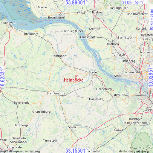
Heinböckel GPS coordinates[2]
53° 34' 28.452" North, 9° 19' 35.184" East
| Map corner | latitude | longitude |
|---|---|---|
| Upper-left | 53.99001°, | 8.62331° |
| Center: | 53.57457°, | 9.32644° |
| Lower-right: | 53.15501°, | 10.02957° |
| Map W x H: | 92.8×92.8 km | = 57.7×57.7mi |
| max Lat: | 55.01917° ⇑13.4% North |
| Heinböckel: | 53.57457° |
| min Lat: | ⇓86.6% South 47.40724° |
| min Long | Heinböckel | max Long |
| 5.92978° | 9.32644° | 14.98853° |
| W 39.6%⇐ | ⇒60.4% E |
Elevation
Elevation of Heinböckel is 17 m = 56 ft, and this is 232.1 m = 761 ft below average elevation for this country.
| Max E: |
1256 m = 4121 ft | 91.6% |
| Avg. | 249.1 m = 817 ft | |
| Heinböckel | 17 m = 56 ft | |
Min E: |
-5 m = -16 ft | 8.4% |
See also: Germany elevation on elevation.city.
Geographical zone
Heinböckel is located in North temperate zone (between Tropic of Cancer and the Arctic Circle). Distance of this North polar circle is 1444.2 km =897.4 mi to North.| Distance of | km | miles | from Heinböckel |
|---|---|---|---|
| North Pole | 4050.1 | 2516.6 | to North |
| Arctic Circle | 1444.2 | 897.4 | to North |
| Tropic Cancer | 3351 | 2082.2 | to South |
| Equator | 5956.9 | 3701.4 | to South |


Nearby cities:
15 places around Heinböckel: (largest is in red/bold)
• Agathenburg
13.6 km =8.5 mi,  96°
96°
• Brest
14.4 km =8.9 mi,  164°
164°
• Burweg
6.8 km =4.2 mi,  324°
324°
• Deinste
9.3 km =5.8 mi,  123°
123°
• Düdenbüttel
2.4 km =1.5 mi,  41°
41°
• Engelschoff
10.3 km =6.4 mi,  2°
2°
• Estorf
8.2 km =5.1 mi,  271°
271°
• Großenwörden
12.7 km =7.9 mi,  341°
341°
• Hammah
5.4 km =3.4 mi,  29°
29°
• Hechthausen
9.3 km =5.8 mi, 321°
• Himmelpforten
4.6 km =2.9 mi, 342°
• Kranenburg
8.7 km =5.4 mi,  294°
294°
• Kutenholz
10.4 km =6.5 mi,  181°
181°
• Oldendorf
5.1 km =3.2 mi,  280°
280°
• Stade
10.1 km =6.3 mi,  78°
78°
Sources, notices
• [Note1] Compared only with cities in Germany existing in our database
• [Src1] Map data: © OpenStreetMap contributors (CC-BY-SA)
• [Src2] Other city data from geonames.org with taken over terms of usage.
• [Src3] Geographical zone / Annual Mean Temperature by Robert A. Rohde @ Wikipedia
