Könnern geodata
Könnern (Saxony-Anhalt) is a populated place; located in Germany in Europe/Berlin (GMT+2) time zone. With population of 5,339 people, there are 2686 cities with bigger population in this country. Compared to other cities in Germany, 68.6% of cities are located further ↓South; 78.4% of cities are located further ←West and 69% of cities have higher elevation than Könnern. Note1


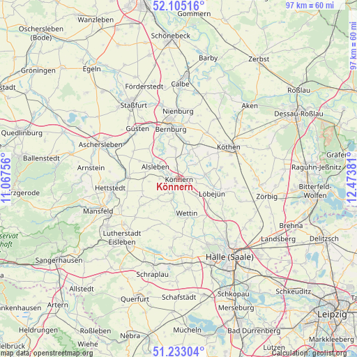
Könnern GPS coordinates[2]
51° 40' 16.32" North, 11° 46' 14.448" East
| Map corner | latitude | longitude |
|---|---|---|
| Upper-left | 52.10516°, | 11.06756° |
| Center: | 51.6712°, | 11.77068° |
| Lower-right: | 51.23304°, | 12.47381° |
| Map W x H: | 97×97 km | = 60.3×60.3mi |
| max Lat: | 55.01917° ⇑31.4% North |
| Könnern: | 51.6712° |
| min Lat: | ⇓68.6% South 47.40724° |
| min Long | Könnern | max Long |
| 5.92978° | 11.77068° | 14.98853° |
| W 78.4%⇐ | ⇒21.6% E |
Elevation
Elevation of Könnern is 97 m = 318 ft, and this is 152.1 m = 499 ft below average elevation for this country.
| Max E: |
1256 m = 4121 ft | 69% |
| Avg. | 249.1 m = 817 ft | |
| Könnern | 97 m = 318 ft | |
Min E: |
-5 m = -16 ft | 31% |
See also: Germany elevation on elevation.city.
Geographical zone
Könnern is located in North temperate zone (between Tropic of Cancer and the Arctic Circle). Distance of this North polar circle is 1655.9 km =1028.9 mi to North.| Distance of | km | miles | from Könnern |
|---|---|---|---|
| North Pole | 4261.8 | 2648.2 | to North |
| Arctic Circle | 1655.9 | 1028.9 | to North |
| Tropic Cancer | 3139.4 | 1950.7 | to South |
| Equator | 5745.3 | 3570 | to South |


Nearby cities:
15 places around Könnern: (largest is in red/bold)
• Alsleben
7.3 km =4.5 mi,  297°
297°
• Beesenlaublingen
6.8 km =4.2 mi,  312°
312°
• Belleben
9.4 km =5.8 mi,  272°
272°
• Cörmigk
7.9 km =4.9 mi,  37°
37°
• Domnitz
6.5 km =4 mi,  133°
133°
• Edlau
3.2 km =2 mi,  99°
99°
• Friedeburg
5.9 km =3.7 mi,  199°
199°
• Gröbzig
7.3 km =4.5 mi,  80°
80°
• Kloschwitz
9.6 km =6 mi,  186°
186°
• Löbejün
9.8 km =6.1 mi,  113°
113°
• Neutz-Lettewitz
8.7 km =5.4 mi,  146°
146°
• Peißen
8.1 km =5 mi,  353°
353°
• Preußlitz
7.4 km =4.6 mi,  22°
22°
• Rothenburg
3 km =1.9 mi, 200°
• Wettin
9.8 km =6.1 mi,  165°
165°
Sources, notices
• [Note1] Compared only with cities in Germany existing in our database
• [Src1] Map data: © OpenStreetMap contributors (CC-BY-SA)
• [Src2] Other city data from geonames.org with taken over terms of usage.
• [Src3] Geographical zone / Annual Mean Temperature by Robert A. Rohde @ Wikipedia
