Friedeburg geodata
Friedeburg (Saxony-Anhalt) is a populated place; located in Germany in Europe/Berlin (GMT+2) time zone. With population of 527 people, there are 9209 cities with bigger population in this country. Compared to other cities in Germany, 68% of cities are located further ↓South; 77.9% of cities are located further ←West and 70.7% of cities have higher elevation than Friedeburg. Note1


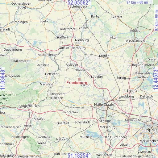
Friedeburg GPS coordinates[2]
51° 37' 16.248" North, 11° 44' 33.36" East
| Map corner | latitude | longitude |
|---|---|---|
| Upper-left | 52.05562°, | 11.03948° |
| Center: | 51.62118°, | 11.7426° |
| Lower-right: | 51.18254°, | 12.44573° |
| Map W x H: | 97.1×97.1 km | = 60.3×60.3mi |
| max Lat: | 55.01917° ⇑32% North |
| Friedeburg: | 51.62118° |
| min Lat: | ⇓68% South 47.40724° |
| min Long | Friedeburg | max Long |
| 5.92978° | 11.7426° | 14.98853° |
| W 77.9%⇐ | ⇒22.1% E |
Elevation
Elevation of Friedeburg is 87 m = 285 ft, and this is 162.1 m = 532 ft below average elevation for this country.
| Max E: |
1256 m = 4121 ft | 70.7% |
| Avg. | 249.1 m = 817 ft | |
| Friedeburg | 87 m = 285 ft | |
Min E: |
-5 m = -16 ft | 29.3% |
See also: Germany elevation on elevation.city.
Geographical zone
Friedeburg is located in North temperate zone (between Tropic of Cancer and the Arctic Circle). Distance of this North polar circle is 1661.4 km =1032.3 mi to North.| Distance of | km | miles | from Friedeburg |
|---|---|---|---|
| North Pole | 4267.3 | 2651.6 | to North |
| Arctic Circle | 1661.4 | 1032.3 | to North |
| Tropic Cancer | 3133.8 | 1947.3 | to South |
| Equator | 5739.7 | 3566.5 | to South |


Nearby cities:
15 places around Friedeburg: (largest is in red/bold)
• Alsleben
10 km =6.2 mi,  332°
332°
• Beesenstedt
5.9 km =3.7 mi,  186°
186°
• Belleben
9.6 km =6 mi,  308°
308°
• Domnitz
6.7 km =4.2 mi,  80°
80°
• Edlau
7.2 km =4.5 mi,  45°
45°
• Gerbstedt
8.1 km =5 mi,  279°
279°
• Hedersleben
10.3 km =6.4 mi,  218°
218°
• Heiligenthal
7.7 km =4.8 mi,  259°
259°
• Kloschwitz
4.1 km =2.5 mi,  166°
166°
• Könnern
5.9 km =3.7 mi,  19°
19°
• Nauendorf
10.1 km =6.3 mi,  102°
102°
• Neutz-Lettewitz
7 km =4.3 mi, 104°
• Rothenburg
2.9 km =1.8 mi, 18°
• Schochwitz
10 km =6.2 mi,  175°
175°
• Wettin
5.9 km =3.7 mi,  131°
131°
Sources, notices
• [Note1] Compared only with cities in Germany existing in our database
• [Src1] Map data: © OpenStreetMap contributors (CC-BY-SA)
• [Src2] Other city data from geonames.org with taken over terms of usage.
• [Src3] Geographical zone / Annual Mean Temperature by Robert A. Rohde @ Wikipedia
