Rothenburg geodata
Rothenburg (Saxony-Anhalt) is a populated place; located in Germany in Europe/Berlin (GMT+2) time zone. With population of 940 people, there are 7391 cities with bigger population in this country. Compared to other cities in Germany, 68.2% of cities are located further ↓South; 78.1% of cities are located further ←West and 71.8% of cities have higher elevation than Rothenburg. Note1


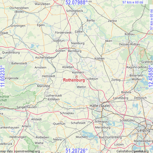
Rothenburg GPS coordinates[2]
51° 38' 44.412" North, 11° 45' 19.62" East
| Map corner | latitude | longitude |
|---|---|---|
| Upper-left | 52.07988°, | 11.05233° |
| Center: | 51.64567°, | 11.75545° |
| Lower-right: | 51.20726°, | 12.45858° |
| Map W x H: | 97×97 km | = 60.3×60.3mi |
| max Lat: | 55.01917° ⇑31.8% North |
| Rothenburg: | 51.64567° |
| min Lat: | ⇓68.2% South 47.40724° |
| min Long | Rothenburg | max Long |
| 5.92978° | 11.75545° | 14.98853° |
| W 78.1%⇐ | ⇒21.9% E |
Elevation
Elevation of Rothenburg is 79 m = 259 ft, and this is 170.1 m = 558 ft below average elevation for this country.
| Max E: |
1256 m = 4121 ft | 71.8% |
| Avg. | 249.1 m = 817 ft | |
| Rothenburg | 79 m = 259 ft | |
Min E: |
-5 m = -16 ft | 28.2% |
See also: Germany elevation on elevation.city.
Geographical zone
Rothenburg is located in North temperate zone (between Tropic of Cancer and the Arctic Circle). Distance of this North polar circle is 1658.7 km =1030.7 mi to North.| Distance of | km | miles | from Rothenburg |
|---|---|---|---|
| North Pole | 4264.6 | 2649.9 | to North |
| Arctic Circle | 1658.7 | 1030.7 | to North |
| Tropic Cancer | 3136.5 | 1948.9 | to South |
| Equator | 5742.5 | 3568.2 | to South |


Nearby cities:
15 places around Rothenburg: (largest is in red/bold)
• Alsleben
8.3 km =5.2 mi,  318°
318°
• Beesenlaublingen
8.5 km =5.3 mi,  331°
331°
• Beesenstedt
8.7 km =5.4 mi,  190°
190°
• Belleben
9 km =5.6 mi,  291°
291°
• Domnitz
6 km =3.7 mi,  105°
105°
• Edlau
4.8 km =3 mi,  61°
61°
• Friedeburg
2.9 km =1.8 mi,  198°
198°
• Gerbstedt
9 km =5.6 mi,  260°
260°
• Gröbzig
9.2 km =5.7 mi, 63°
• Heiligenthal
9.4 km =5.8 mi,  243°
243°
• Kloschwitz
6.7 km =4.2 mi,  179°
179°
• Könnern
3 km =1.9 mi,  20°
20°
• Löbejün
10.1 km =6.3 mi,  96°
96°
• Neutz-Lettewitz
7.4 km =4.6 mi,  127°
127°
• Wettin
7.5 km =4.7 mi,  152°
152°
Sources, notices
• [Note1] Compared only with cities in Germany existing in our database
• [Src1] Map data: © OpenStreetMap contributors (CC-BY-SA)
• [Src2] Other city data from geonames.org with taken over terms of usage.
• [Src3] Geographical zone / Annual Mean Temperature by Robert A. Rohde @ Wikipedia
