Köln geodata
Köln (North Rhine-Westphalia) is a seat of a second-order administrative division; located in Germany in Europe/Berlin (GMT+2) time zone. With population of 963,395 people, there are 3 cities with bigger population in this country. Compared to other cities in Germany, 56.8% of cities are located further ↓South; 94% of cities are located further →East and 76.4% of cities have higher elevation than Köln. Note1
Administrative division(s):
- Level 1: North Rhine-Westphalia
- Level 2: Regierungsbezirk Köln
- Level 3: Kreisfreie Stadt Köln
- Level 4: Köln


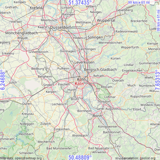
Köln GPS coordinates[2]
50° 55' 59.988" North, 6° 57' 0" East
| Map corner | latitude | longitude |
|---|---|---|
| Upper-left | 51.37435°, | 6.24688° |
| Center: | 50.93333°, | 6.95° |
| Lower-right: | 50.48809°, | 7.65313° |
| Map W x H: | 98.5×98.5 km | = 61.2×61.2mi |
| max Lat: | 55.01917° ⇑43.2% North |
| Köln: | 50.93333° |
| min Lat: | ⇓56.8% South 47.40724° |
| min Long | Köln | max Long |
| 5.92978° | 6.95° | 14.98853° |
| W 6%⇐ | ⇒94% E |
Elevation
Elevation of Köln is 58 m = 190 ft, and this is 191.1 m = 627 ft below average elevation for this country.
| Max E: |
1256 m = 4121 ft | 76.4% |
| Avg. | 249.1 m = 817 ft | |
| Köln | 58 m = 190 ft | |
Min E: |
-5 m = -16 ft | 23.6% |
See also: Köln elevation on elevation.city.
Geographical zone
Köln is located in North temperate zone (between Tropic of Cancer and the Arctic Circle). Distance of this North polar circle is 1737.9 km =1079.9 mi to North.| Distance of | km | miles | from Köln |
|---|---|---|---|
| North Pole | 4343.8 | 2699.1 | to North |
| Arctic Circle | 1737.9 | 1079.9 | to North |
| Tropic Cancer | 3057.3 | 1899.7 | to South |
| Equator | 5663.3 | 3519 | to South |


Nearby cities:
15 places around Köln: (largest is in red/bold)
• Altstadt Nord
0.8 km =0.5 mi,  40°
40°
• Altstadt Sud
0.7 km =0.4 mi,  90°
90°
• Bayenthal
2.7 km =1.7 mi,  151°
151°
• Bilderstoeckchen
4.3 km =2.7 mi,  340°
340°
• Buchforst
4.4 km =2.7 mi,  63°
63°
• Deutz
1.8 km =1.1 mi, 85°
• Humboldtkolonie
3.1 km =1.9 mi, 93°
• Kalk
4 km =2.5 mi,  79°
79°
• Neuehrenfeld
2.9 km =1.8 mi, 340°
• Neustadt/Nord
1.7 km =1.1 mi,  355°
355°
• Neustadt/Süd
0.9 km =0.6 mi,  190°
190°
• Nippes
3.6 km =2.2 mi,  3°
3°
• Ossendorf
5.2 km =3.2 mi,  323°
323°
• Poll
3.7 km =2.3 mi,  129°
129°
• Riehl
4.1 km =2.5 mi,  25°
25°
In other languages:
- In Spanish: Colonia
- In France: Cologne
- In Italian: Colonia
- In Russian: Кёльн
- In Chinese: 科隆
Sources, notices
• [Note1] Compared only with cities in Germany existing in our database
• [Src1] Map data: © OpenStreetMap contributors (CC-BY-SA)
• [Src2] Other city data from geonames.org with taken over terms of usage.
• [Src3] Geographical zone / Annual Mean Temperature by Robert A. Rohde @ Wikipedia
