Kollmoor geodata
Kollmoor (Schleswig-Holstein) is a seat of a fourth-order administrative division; located in Germany in Europe/Berlin (GMT+2) time zone. With population of 36 people, there are 10990 cities with bigger population in this country. Compared to other cities in Germany, 91.6% of cities are located further ↓South; 56.3% of cities are located further →East and 99.5% of cities have higher elevation than Kollmoor. Note1


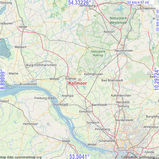
Kollmoor GPS coordinates[2]
53° 55' 12.828" North, 9° 35' 38.796" East
| Map corner | latitude | longitude |
|---|---|---|
| Upper-left | 54.33226°, | 8.89099° |
| Center: | 53.92023°, | 9.59411° |
| Lower-right: | 53.5041°, | 10.29724° |
| Map W x H: | 92.1×92.1 km | = 57.2×57.2mi |
| max Lat: | 55.01917° ⇑8.4% North |
| Kollmoor: | 53.92023° |
| min Lat: | ⇓91.6% South 47.40724° |
| min Long | Kollmoor | max Long |
| 5.92978° | 9.59411° | 14.98853° |
| W 43.7%⇐ | ⇒56.3% E |
Elevation
Elevation of Kollmoor is -1 m = -3 ft, and this is 250.1 m = 821 ft below average elevation for this country.
| Max E: |
1256 m = 4121 ft | 99.5% |
| Avg. | 249.1 m = 817 ft | |
| Kollmoor | -1 m = -3 ft | |
Min E: |
-5 m = -16 ft | 0.5% |
See also: Germany elevation on elevation.city.
Geographical zone
Kollmoor is located in North temperate zone (between Tropic of Cancer and the Arctic Circle). Distance of this North polar circle is 1405.8 km =873.5 mi to North.| Distance of | km | miles | from Kollmoor |
|---|---|---|---|
| North Pole | 4011.7 | 2492.8 | to North |
| Arctic Circle | 1405.8 | 873.5 | to North |
| Tropic Cancer | 3389.4 | 2106.1 | to South |
| Equator | 5995.4 | 3725.4 | to South |


Nearby cities:
15 places around Kollmoor: (largest is in red/bold)
• Auufer
5.8 km =3.6 mi,  85°
85°
• Breitenberg
2.7 km =1.7 mi,  80°
80°
• Breitenburg
2.2 km =1.4 mi,  223°
223°
• Dägeling
5.7 km =3.5 mi, 224°
• Hohenlockstedt
5.4 km =3.4 mi,  15°
15°
• Itzehoe
5.2 km =3.2 mi,  270°
270°
• Kronsmoor
1.4 km =0.9 mi,  180°
180°
• Lohbarbek
3.9 km =2.4 mi,  43°
43°
• Lägerdorf
4.2 km =2.6 mi,  189°
189°
• Moordiek
3.9 km =2.4 mi,  100°
100°
• Münsterdorf
4 km =2.5 mi,  240°
240°
• Oelixdorf
2.1 km =1.3 mi,  291°
291°
• Schlotfeld
4.1 km =2.5 mi,  349°
349°
• Westermoor
2.1 km =1.3 mi,  110°
110°
• Winseldorf
2.8 km =1.7 mi, 16°
Sources, notices
• [Note1] Compared only with cities in Germany existing in our database
• [Src1] Map data: © OpenStreetMap contributors (CC-BY-SA)
• [Src2] Other city data from geonames.org with taken over terms of usage.
• [Src3] Geographical zone / Annual Mean Temperature by Robert A. Rohde @ Wikipedia
