Itzehoe geodata
Itzehoe (Schleswig-Holstein) is a seat of a third-order administrative division; located in Germany in Europe/Berlin (GMT+2) time zone. With population of 33,047 people, there are 409 cities with bigger population in this country. Compared to other cities in Germany, 91.6% of cities are located further ↓South; 57.6% of cities are located further →East and 95.6% of cities have higher elevation than Itzehoe. Note1


Itzehoe GPS coordinates[2]
53° 55' 15.564" North, 9° 30' 55.044" East
| Map corner | latitude | longitude |
|---|---|---|
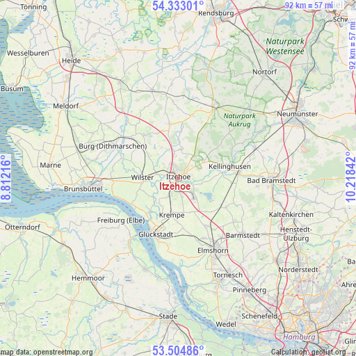
| Upper-left | 54.33301°, | 8.81216° |
| Center: | 53.92099°, | 9.51529° |
| Lower-right: | 53.50486°, | 10.21842° |
| Map W x H: | 92.1×92.1 km | = 57.2×57.2mi |
| max Lat: | 55.01917° ⇑8.4% North |
| Itzehoe: | 53.92099° |
| min Lat: | ⇓91.6% South 47.40724° |
| min Long | Itzehoe | max Long |
| 5.92978° | 9.51529° | 14.98853° |
| W 42.4%⇐ | ⇒57.6% E |
Elevation
Elevation of Itzehoe is 7 m = 23 ft, and this is 242.1 m = 794 ft below average elevation for this country.
| Max E: |
1256 m = 4121 ft | 95.6% |
| Avg. | 249.1 m = 817 ft | |
| Itzehoe | 7 m = 23 ft | |
Min E: |
-5 m = -16 ft | 4.4% |
See also: Germany elevation on elevation.city.
Geographical zone
Itzehoe is located in North temperate zone (between Tropic of Cancer and the Arctic Circle). Distance of this North polar circle is 1405.7 km =873.5 mi to North.| Distance of | km | miles | from Itzehoe |
|---|---|---|---|
| North Pole | 4011.6 | 2492.7 | to North |
| Arctic Circle | 1405.7 | 873.5 | to North |
| Tropic Cancer | 3389.5 | 2106.1 | to South |
| Equator | 5995.5 | 3725.4 | to South |


Nearby cities:
15 places around Itzehoe: (largest is in red/bold)
• Bekmünde
4.5 km =2.8 mi,  275°
275°
• Breitenburg
4 km =2.5 mi,  115°
115°
• Dägeling
4.4 km =2.7 mi,  164°
164°
• Heiligenstedten
3 km =1.9 mi,  295°
295°
• Heiligenstedtenerkamp
3.9 km =2.4 mi,  232°
232°
• Kollmoor
5.2 km =3.2 mi,  90°
90°
• Kremperheide
4.5 km =2.8 mi,  212°
212°
• Krempermoor
5.4 km =3.4 mi,  204°
204°
• Kronsmoor
5.4 km =3.4 mi,  106°
106°
• Münsterdorf
2.7 km =1.7 mi,  140°
140°
• Oelixdorf
3.3 km =2.1 mi,  77°
77°
• Oldendorf
5.2 km =3.2 mi,  314°
314°
• Ottenbüttel
5.6 km =3.5 mi,  352°
352°
• Schlotfeld
5.9 km =3.7 mi,  48°
48°
• Stördorf
5.9 km =3.7 mi,  263°
263°
Sources, notices
• [Note1] Compared only with cities in Germany existing in our database
• [Src1] Map data: © OpenStreetMap contributors (CC-BY-SA)
• [Src2] Other city data from geonames.org with taken over terms of usage.
• [Src3] Geographical zone / Annual Mean Temperature by Robert A. Rohde @ Wikipedia
