Dägeling geodata
Dägeling (Schleswig-Holstein) is a seat of a fourth-order administrative division; located in Germany in Europe/Berlin (GMT+2) time zone. With population of 1,048 people, there are 7013 cities with bigger population in this country. Compared to other cities in Germany, 91% of cities are located further ↓South; 57.3% of cities are located further →East and 91.2% of cities have higher elevation than Dägeling. Note1


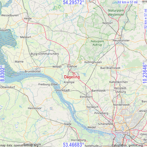
Dägeling GPS coordinates[2]
53° 52' 59.988" North, 9° 31' 59.988" East
| Map corner | latitude | longitude |
|---|---|---|
| Upper-left | 54.29572°, | 8.8302° |
| Center: | 53.88333°, | 9.53333° |
| Lower-right: | 53.46683°, | 10.23646° |
| Map W x H: | 92.2×92.2 km | = 57.3×57.3mi |
| max Lat: | 55.01917° ⇑9% North |
| Dägeling: | 53.88333° |
| min Lat: | ⇓91% South 47.40724° |
| min Long | Dägeling | max Long |
| 5.92978° | 9.53333° | 14.98853° |
| W 42.7%⇐ | ⇒57.3% E |
Elevation
Elevation of Dägeling is 18 m = 59 ft, and this is 231.1 m = 758 ft below average elevation for this country.
| Max E: |
1256 m = 4121 ft | 91.2% |
| Avg. | 249.1 m = 817 ft | |
| Dägeling | 18 m = 59 ft | |
Min E: |
-5 m = -16 ft | 8.8% |
See also: Germany elevation on elevation.city.
Geographical zone
Dägeling is located in North temperate zone (between Tropic of Cancer and the Arctic Circle). Distance of this North polar circle is 1409.9 km =876.1 mi to North.| Distance of | km | miles | from Dägeling |
|---|---|---|---|
| North Pole | 4015.8 | 2495.3 | to North |
| Arctic Circle | 1409.9 | 876.1 | to North |
| Tropic Cancer | 3385.3 | 2103.5 | to South |
| Equator | 5991.3 | 3722.8 | to South |


Nearby cities:
15 places around Dägeling: (largest is in red/bold)
• Bahrenfleth
6.3 km =3.9 mi,  257°
257°
• Breitenburg
3.5 km =2.2 mi,  44°
44°
• Grevenkop
4.5 km =2.8 mi,  179°
179°
• Heiligenstedtenerkamp
4.6 km =2.9 mi,  292°
292°
• Itzehoe
4.4 km =2.7 mi,  344°
344°
• Kollmoor
5.7 km =3.5 mi, 44°
• Krempe
5.9 km =3.7 mi,  209°
209°
• Kremperheide
3.6 km =2.2 mi,  276°
276°
• Krempermoor
3.5 km =2.2 mi, 258°
• Kronsmoor
4.8 km =3 mi,  55°
55°
• Lägerdorf
3.3 km =2.1 mi,  90°
90°
• Münsterdorf
2.2 km =1.4 mi,  13°
13°
• Neuenbrook
2.5 km =1.6 mi, 181°
• Oelixdorf
5.3 km =3.3 mi,  22°
22°
• Rethwisch
3.9 km =2.4 mi,  117°
117°
Sources, notices
• [Note1] Compared only with cities in Germany existing in our database
• [Src1] Map data: © OpenStreetMap contributors (CC-BY-SA)
• [Src2] Other city data from geonames.org with taken over terms of usage.
• [Src3] Geographical zone / Annual Mean Temperature by Robert A. Rohde @ Wikipedia
