Kohlberg geodata
Kohlberg (Baden-Württemberg) is a seat of a fourth-order administrative division; located in Germany in Europe/Berlin (GMT+2) time zone. With population of 2,304 people, there are 4663 cities with bigger population in this country. Compared to other cities in Germany, 88.4% of cities are located further ↑North; 60.2% of cities are located further →East and 84.9% of cities have lower elevation than Kohlberg. Note1
Administrative division(s):
- Level 1: Baden-Württemberg
- Level 2: Regierungsbezirk Stuttgart
- Level 3: Landkreis Esslingen
- Level 4: Kohlberg


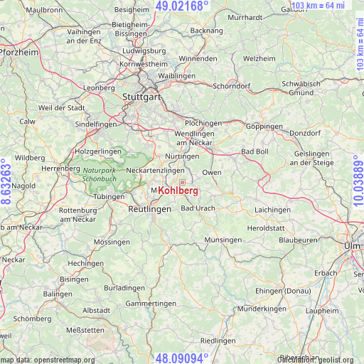
Kohlberg GPS coordinates[2]
48° 33' 30.42" North, 9° 20' 8.736" East
| Map corner | latitude | longitude |
|---|---|---|
| Upper-left | 49.02168°, | 8.63263° |
| Center: | 48.55845°, | 9.33576° |
| Lower-right: | 48.09094°, | 10.03889° |
| Map W x H: | 103.5×103.5 km | = 64.3×64.3mi |
| max Lat: | 55.01917° ⇑88.4% North |
| Kohlberg: | 48.55845° |
| min Lat: | ⇓11.6% South 47.40724° |
| min Long | Kohlberg | max Long |
| 5.92978° | 9.33576° | 14.98853° |
| W 39.8%⇐ | ⇒60.2% E |
Elevation
Elevation of Kohlberg is 468 m = 1535 ft, and this is 218.9 m = 718 ft above average elevation for this country.
| Max E: |
1256 m = 4121 ft | 15.1% |
| Kohlberg | 468 m 1535 ft | |
| Avg. | 249.1 m = 817 ft | |
Min E: |
-5 m = -16 ft | 84.9% |
See also: Germany elevation on elevation.city.
Geographical zone
Kohlberg is located in North temperate zone (between Tropic of Cancer and the Arctic Circle). Distance of this North polar circle is 2002 km =1244 mi to North.| Distance of | km | miles | from Kohlberg |
|---|---|---|---|
| North Pole | 4607.9 | 2863.2 | to North |
| Arctic Circle | 2002 | 1244 | to North |
| Tropic Cancer | 2793.3 | 1735.7 | to South |
| Equator | 5399.2 | 3354.9 | to South |


Nearby cities:
15 places around Kohlberg: (largest is in red/bold)
• Altdorf
6.2 km =3.9 mi,  310°
310°
• Bad Urach
8.9 km =5.5 mi,  147°
147°
• Bempflingen
5.2 km =3.2 mi,  286°
286°
• Beuren
5.2 km =3.2 mi,  76°
76°
• Dettingen an der Erms
3.1 km =1.9 mi,  168°
168°
• Erkenbrechtsweiler
7.1 km =4.4 mi,  91°
91°
• Frickenhausen
4.3 km =2.7 mi,  24°
24°
• Großbettlingen
4.1 km =2.5 mi,  330°
330°
• Hülben
6.8 km =4.2 mi,  128°
128°
• Metzingen
4.5 km =2.8 mi,  238°
238°
• Neckartailfingen
7.9 km =4.9 mi,  318°
318°
• Neckartenzlingen
8.2 km =5.1 mi,  295°
295°
• Neuffen
3 km =1.9 mi,  98°
98°
• Nürtingen
7.5 km =4.7 mi,  3°
3°
• Riederich
4.9 km =3 mi,  272°
272°
Sources, notices
• [Note1] Compared only with cities in Germany existing in our database
• [Src1] Map data: © OpenStreetMap contributors (CC-BY-SA)
• [Src2] Other city data from geonames.org with taken over terms of usage.
• [Src3] Geographical zone / Annual Mean Temperature by Robert A. Rohde @ Wikipedia
