Klingenmünster geodata
Klingenmünster (Rheinland-Pfalz) is a seat of a fourth-order administrative division; located in Germany in Europe/Berlin (GMT+2) time zone. With population of 2,432 people, there are 4525 cities with bigger population in this country. Compared to other cities in Germany, 81.3% of cities are located further ↑North; 76.8% of cities are located further →East and 57.2% of cities have higher elevation than Klingenmünster. Note1
Administrative division(s):
- Level 1: Rheinland-Pfalz
- Level 3: Landkreis Südliche Weinstraße
- Level 4: Klingenmünster


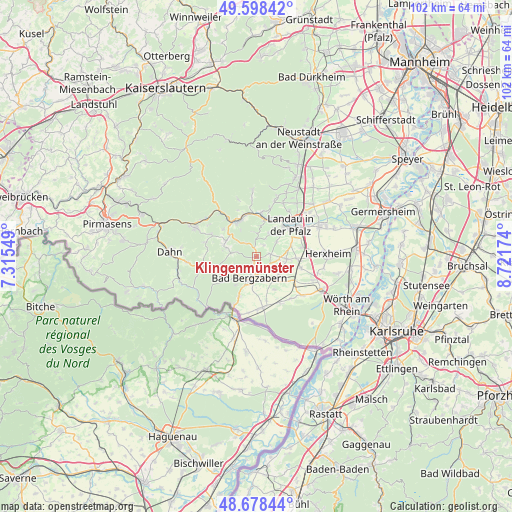
Klingenmünster GPS coordinates[2]
49° 8' 26.016" North, 8° 1' 6.996" East
| Map corner | latitude | longitude |
|---|---|---|
| Upper-left | 49.59842°, | 7.31549° |
| Center: | 49.14056°, | 8.01861° |
| Lower-right: | 48.67844°, | 8.72174° |
| Map W x H: | 102.3×102.3 km | = 63.6×63.6mi |
| max Lat: | 55.01917° ⇑81.3% North |
| Klingenmünster: | 49.14056° |
| min Lat: | ⇓18.7% South 47.40724° |
| min Long | Klingenmünster | max Long |
| 5.92978° | 8.01861° | 14.98853° |
| W 23.2%⇐ | ⇒76.8% E |
Elevation
Elevation of Klingenmünster is 173 m = 568 ft, and this is 76.1 m = 250 ft below average elevation for this country.
| Max E: |
1256 m = 4121 ft | 57.2% |
| Avg. | 249.1 m = 817 ft | |
| Klingenmünster | 173 m = 568 ft | |
Min E: |
-5 m = -16 ft | 42.8% |
See also: Germany elevation on elevation.city.
Geographical zone
Klingenmünster is located in North temperate zone (between Tropic of Cancer and the Arctic Circle). Distance of this North polar circle is 1937.3 km =1203.8 mi to North.| Distance of | km | miles | from Klingenmünster |
|---|---|---|---|
| North Pole | 4543.1 | 2823 | to North |
| Arctic Circle | 1937.3 | 1203.8 | to North |
| Tropic Cancer | 2858 | 1775.9 | to South |
| Equator | 5463.9 | 3395.1 | to South |


Nearby cities:
15 places around Klingenmünster: (largest is in red/bold)
• Bad Bergzabern
4.4 km =2.7 mi,  196°
196°
• Billigheim-Ingenheim
5.3 km =3.3 mi,  94°
94°
• Eschbach
3.8 km =2.4 mi,  0°
0°
• Gleiszellen-Gleishorbach
1.9 km =1.2 mi,  210°
210°
• Göcklingen
2.9 km =1.8 mi,  34°
34°
• Heuchelheim-Klingen
2.7 km =1.7 mi,  78°
78°
• Ilbesheim
5.3 km =3.3 mi, 28°
• Kapellen-Drusweiler
4.4 km =2.7 mi,  168°
168°
• Leinsweiler
4.8 km =3 mi, 0°
• Münchweiler am Klingbach
3.9 km =2.4 mi,  285°
285°
• Niederhorbach
3 km =1.9 mi,  158°
158°
• Pleisweiler-Oberhofen
2.6 km =1.6 mi, 197°
• Silz
5.1 km =3.2 mi,  281°
281°
• Waldhambach
3.9 km =2.4 mi,  318°
318°
• Waldrohrbach
4.8 km =3 mi,  307°
307°
Sources, notices
• [Note1] Compared only with cities in Germany existing in our database
• [Src1] Map data: © OpenStreetMap contributors (CC-BY-SA)
• [Src2] Other city data from geonames.org with taken over terms of usage.
• [Src3] Geographical zone / Annual Mean Temperature by Robert A. Rohde @ Wikipedia
