Göcklingen geodata
Göcklingen (Rheinland-Pfalz) is a seat of a fourth-order administrative division; located in Germany in Europe/Berlin (GMT+2) time zone. With population of 972 people, there are 7264 cities with bigger population in this country. Compared to other cities in Germany, 80.9% of cities are located further ↑North; 76.4% of cities are located further →East and 56.2% of cities have higher elevation than Göcklingen. Note1
Administrative division(s):
- Level 1: Rheinland-Pfalz
- Level 3: Landkreis Südliche Weinstraße
- Level 4: Göcklingen


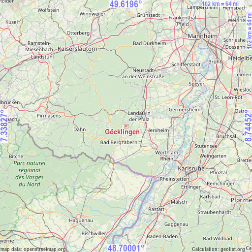
Göcklingen GPS coordinates[2]
49° 9' 42.984" North, 8° 2' 29.004" East
| Map corner | latitude | longitude |
|---|---|---|
| Upper-left | 49.6196°, | 7.33827° |
| Center: | 49.16194°, | 8.04139° |
| Lower-right: | 48.70001°, | 8.74452° |
| Map W x H: | 102.2×102.2 km | = 63.5×63.5mi |
| max Lat: | 55.01917° ⇑80.9% North |
| Göcklingen: | 49.16194° |
| min Lat: | ⇓19.1% South 47.40724° |
| min Long | Göcklingen | max Long |
| 5.92978° | 8.04139° | 14.98853° |
| W 23.6%⇐ | ⇒76.4% E |
Elevation
Elevation of Göcklingen is 180 m = 591 ft, and this is 69.1 m = 227 ft below average elevation for this country.
| Max E: |
1256 m = 4121 ft | 56.2% |
| Avg. | 249.1 m = 817 ft | |
| Göcklingen | 180 m = 591 ft | |
Min E: |
-5 m = -16 ft | 43.8% |
See also: Germany elevation on elevation.city.
Geographical zone
Göcklingen is located in North temperate zone (between Tropic of Cancer and the Arctic Circle). Distance of this North polar circle is 1934.9 km =1202.3 mi to North.| Distance of | km | miles | from Göcklingen |
|---|---|---|---|
| North Pole | 4540.8 | 2821.5 | to North |
| Arctic Circle | 1934.9 | 1202.3 | to North |
| Tropic Cancer | 2860.4 | 1777.4 | to South |
| Equator | 5466.3 | 3396.6 | to South |


Nearby cities:
15 places around Göcklingen: (largest is in red/bold)
• Billigheim-Ingenheim
4.5 km =2.8 mi,  128°
128°
• Birkweiler
4.6 km =2.9 mi,  357°
357°
• Eschbach
2.1 km =1.3 mi,  310°
310°
• Gleiszellen-Gleishorbach
4.7 km =2.9 mi,  212°
212°
• Heuchelheim-Klingen
2.1 km =1.3 mi,  151°
151°
• Ilbesheim
2.5 km =1.6 mi,  21°
21°
• Impflingen
5.2 km =3.2 mi,  89°
89°
• Klingenmünster
2.9 km =1.8 mi, 214°
• Leinsweiler
2.9 km =1.8 mi,  325°
325°
• Niederhorbach
5.2 km =3.2 mi,  185°
185°
• Pleisweiler-Oberhofen
5.5 km =3.4 mi, 206°
• Ranschbach
3.9 km =2.4 mi,  346°
346°
• Siebeldingen
5.3 km =3.3 mi,  7°
7°
• Waldhambach
4.3 km =2.7 mi,  277°
277°
• Waldrohrbach
5.5 km =3.4 mi, 275°
Sources, notices
• [Note1] Compared only with cities in Germany existing in our database
• [Src1] Map data: © OpenStreetMap contributors (CC-BY-SA)
• [Src2] Other city data from geonames.org with taken over terms of usage.
• [Src3] Geographical zone / Annual Mean Temperature by Robert A. Rohde @ Wikipedia
