Kliding geodata
Kliding (Rheinland-Pfalz) is a seat of a fourth-order administrative division; located in Germany in Europe/Berlin (GMT+2) time zone. With population of 223 people, there are 10380 cities with bigger population in this country. Compared to other cities in Germany, 61% of cities are located further ↑North; 92.8% of cities are located further →East and 77% of cities have lower elevation than Kliding. Note1
Administrative division(s):
- Level 1: Rheinland-Pfalz
- Level 3: Landkreis Cochem-Zell
- Level 4: Kliding


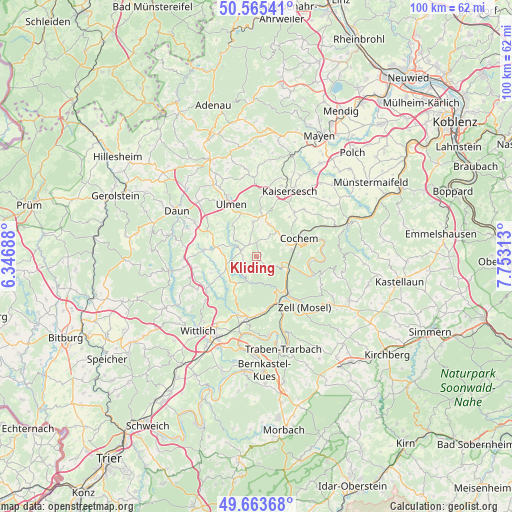
Kliding GPS coordinates[2]
50° 7' 0.012" North, 7° 3' 0" East
| Map corner | latitude | longitude |
|---|---|---|
| Upper-left | 50.56541°, | 6.34688° |
| Center: | 50.11667°, | 7.05° |
| Lower-right: | 49.66368°, | 7.75313° |
| Map W x H: | 100.3×100.3 km | = 62.3×62.3mi |
| max Lat: | 55.01917° ⇑61% North |
| Kliding: | 50.11667° |
| min Lat: | ⇓39% South 47.40724° |
| min Long | Kliding | max Long |
| 5.92978° | 7.05° | 14.98853° |
| W 7.2%⇐ | ⇒92.8% E |
Elevation
Elevation of Kliding is 412 m = 1352 ft, and this is 162.9 m = 534 ft above average elevation for this country.
| Max E: |
1256 m = 4121 ft | 23% |
| Kliding | 412 m 1352 ft | |
| Avg. | 249.1 m = 817 ft | |
Min E: |
-5 m = -16 ft | 77% |
See also: Germany elevation on elevation.city.
Geographical zone
Kliding is located in North temperate zone (between Tropic of Cancer and the Arctic Circle). Distance of this North polar circle is 1828.7 km =1136.3 mi to North.| Distance of | km | miles | from Kliding |
|---|---|---|---|
| North Pole | 4434.6 | 2755.5 | to North |
| Arctic Circle | 1828.7 | 1136.3 | to North |
| Tropic Cancer | 2966.5 | 1843.3 | to South |
| Equator | 5572.5 | 3462.6 | to South |


Nearby cities:
15 places around Kliding: (largest is in red/bold)
• Bad Bertrich
5.7 km =3.5 mi,  192°
192°
• Beuren
3 km =1.9 mi,  127°
127°
• Bremm
5.1 km =3.2 mi,  111°
111°
• Büchel
6.7 km =4.2 mi,  20°
20°
• Dohr
5.3 km =3.3 mi,  74°
74°
• Faid
5.8 km =3.6 mi,  57°
57°
• Gevenich
4.4 km =2.7 mi,  32°
32°
• Gillenbeuren
4.8 km =3 mi,  332°
332°
• Lutzerath
3.2 km =2 mi,  290°
290°
• Neef
6.2 km =3.9 mi, 107°
• Schmitt
6 km =3.7 mi,  336°
336°
• Urschmitt
1.2 km =0.7 mi,  90°
90°
• Wagenhausen
6 km =3.7 mi,  307°
307°
• Weiler
4.4 km =2.7 mi, 32°
• Wollmerath
6 km =3.7 mi, 307°
Sources, notices
• [Note1] Compared only with cities in Germany existing in our database
• [Src1] Map data: © OpenStreetMap contributors (CC-BY-SA)
• [Src2] Other city data from geonames.org with taken over terms of usage.
• [Src3] Geographical zone / Annual Mean Temperature by Robert A. Rohde @ Wikipedia
