Beuren geodata
Beuren (Rheinland-Pfalz) is a seat of a fourth-order administrative division; located in Germany in Europe/Berlin (GMT+2) time zone. In our database, there are 11009 cities with bigger population. Compared to other cities in Germany, 61.4% of cities are located further ↑North; 92.5% of cities are located further →East and 78% of cities have lower elevation than Beuren. Note1


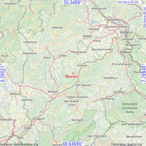
Beuren GPS coordinates[2]
50° 6' 0" North, 7° 4' 59.988" East
| Map corner | latitude | longitude |
|---|---|---|
| Upper-left | 50.5489°, | 6.38021° |
| Center: | 50.1°, | 7.08333° |
| Lower-right: | 49.64686°, | 7.78646° |
| Map W x H: | 100.3×100.3 km | = 62.3×62.3mi |
| max Lat: | 55.01917° ⇑61.4% North |
| Beuren: | 50.1° |
| min Lat: | ⇓38.6% South 47.40724° |
| min Long | Beuren | max Long |
| 5.92978° | 7.08333° | 14.98853° |
| W 7.5%⇐ | ⇒92.5% E |
Elevation
Elevation of Beuren is 419 m = 1375 ft, and this is 169.9 m = 557 ft above average elevation for this country.
| Max E: |
1256 m = 4121 ft | 22% |
| Beuren | 419 m 1375 ft | |
| Avg. | 249.1 m = 817 ft | |
Min E: |
-5 m = -16 ft | 78% |
See also: Germany elevation on elevation.city.
Geographical zone
Beuren is located in North temperate zone (between Tropic of Cancer and the Arctic Circle). Distance of this North polar circle is 1830.6 km =1137.5 mi to North.| Distance of | km | miles | from Beuren |
|---|---|---|---|
| North Pole | 4436.5 | 2756.7 | to North |
| Arctic Circle | 1830.6 | 1137.5 | to North |
| Tropic Cancer | 2964.7 | 1842.2 | to South |
| Equator | 5570.6 | 3461.4 | to South |


Nearby cities:
15 places around Beuren: (largest is in red/bold)
• Alf
5.8 km =3.6 mi,  150°
150°
• Bad Bertrich
5.1 km =3.2 mi,  223°
223°
• Bremm
2.4 km =1.5 mi,  90°
90°
• Bullay
6.4 km =4 mi,  142°
142°
• Dohr
4.2 km =2.6 mi,  39°
39°
• Ediger-Eller
5.1 km =3.2 mi,  68°
68°
• Faid
5.6 km =3.5 mi,  27°
27°
• Gevenich
5.6 km =3.5 mi,  0°
0°
• Kliding
3 km =1.9 mi,  307°
307°
• Lutzerath
6.2 km =3.9 mi,  298°
298°
• Neef
3.6 km =2.2 mi, 90°
• Pünderich
7.4 km =4.6 mi, 154°
• Sankt Aldegund
4 km =2.5 mi,  117°
117°
• Urschmitt
2.2 km =1.4 mi,  327°
327°
• Weiler
5.6 km =3.5 mi, 0°
Sources, notices
• [Note1] Compared only with cities in Germany existing in our database
• [Src1] Map data: © OpenStreetMap contributors (CC-BY-SA)
• [Src2] Other city data from geonames.org with taken over terms of usage.
• [Src3] Geographical zone / Annual Mean Temperature by Robert A. Rohde @ Wikipedia
