Kleineutersdorf geodata
Kleineutersdorf (Thuringia) is a seat of a fourth-order administrative division; located in Germany in Europe/Berlin (GMT+2) time zone. With population of 393 people, there are 9714 cities with bigger population in this country. Compared to other cities in Germany, 53.8% of cities are located further ↓South; 75.5% of cities are located further ←West and 50.3% of cities have lower elevation than Kleineutersdorf. Note1
Administrative division(s):
- Level 1: Thuringia
- Level 3: Saale-Holzland-Kreis
- Level 4: Kleineutersdorf


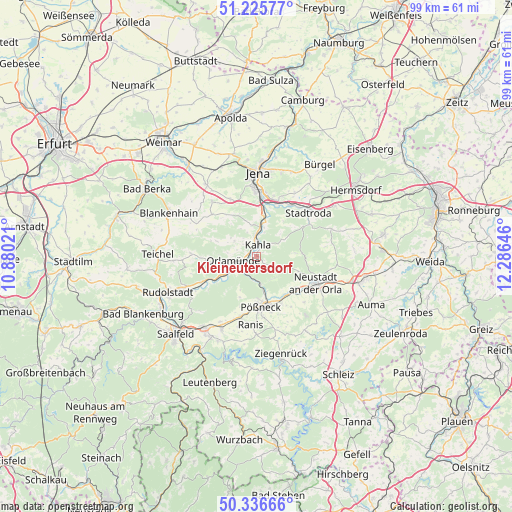
Kleineutersdorf GPS coordinates[2]
50° 46' 59.988" North, 11° 34' 59.988" East
| Map corner | latitude | longitude |
|---|---|---|
| Upper-left | 51.22577°, | 10.88021° |
| Center: | 50.78333°, | 11.58333° |
| Lower-right: | 50.33666°, | 12.28646° |
| Map W x H: | 98.9×98.9 km | = 61.5×61.5mi |
| max Lat: | 55.01917° ⇑46.2% North |
| Kleineutersdorf: | 50.78333° |
| min Lat: | ⇓53.8% South 47.40724° |
| min Long | Kleineutersdorf | max Long |
| 5.92978° | 11.58333° | 14.98853° |
| W 75.5%⇐ | ⇒24.5% E |
Elevation
Elevation of Kleineutersdorf is 228 m = 748 ft, and this is 21.1 m = 69 ft below average elevation for this country.
| Max E: |
1256 m = 4121 ft | 49.7% |
| Avg. | 249.1 m = 817 ft | |
| Kleineutersdorf | 228 m = 748 ft | |
Min E: |
-5 m = -16 ft | 50.3% |
See also: Germany elevation on elevation.city.
Geographical zone
Kleineutersdorf is located in North temperate zone (between Tropic of Cancer and the Arctic Circle). Distance of this North polar circle is 1754.6 km =1090.3 mi to North.| Distance of | km | miles | from Kleineutersdorf |
|---|---|---|---|
| North Pole | 4360.5 | 2709.5 | to North |
| Arctic Circle | 1754.6 | 1090.3 | to North |
| Tropic Cancer | 3040.7 | 1889.4 | to South |
| Equator | 5646.6 | 3508.6 | to South |


Nearby cities:
15 places around Kleineutersdorf: (largest is in red/bold)
• Bibra
3.4 km =2.1 mi,  311°
311°
• Eichenberg
4 km =2.5 mi,  297°
297°
• Freienorla
3 km =1.9 mi,  231°
231°
• Großeutersdorf
1.2 km =0.7 mi,  270°
270°
• Großpürschütz
3.9 km =2.4 mi,  17°
17°
• Gumperda
5.1 km =3.2 mi, 304°
• Hummelshain
4 km =2.5 mi,  117°
117°
• Kahla
2.6 km =1.6 mi,  2°
2°
• Langenorla
4.7 km =2.9 mi,  182°
182°
• Lindig
1.2 km =0.7 mi,  90°
90°
• Oberbodnitz
6.1 km =3.8 mi,  72°
72°
• Orlamünde
4.6 km =2.9 mi,  258°
258°
• Schöps
5.7 km =3.5 mi,  11°
11°
• Seitenroda
3 km =1.9 mi,  51°
51°
• Unterbodnitz
6 km =3.7 mi, 51°
Sources, notices
• [Note1] Compared only with cities in Germany existing in our database
• [Src1] Map data: © OpenStreetMap contributors (CC-BY-SA)
• [Src2] Other city data from geonames.org with taken over terms of usage.
• [Src3] Geographical zone / Annual Mean Temperature by Robert A. Rohde @ Wikipedia
