Orlamünde geodata
Orlamünde (Thuringia) is a populated place; located in Germany in Europe/Berlin (GMT+2) time zone. With population of 1,283 people, there are 6354 cities with bigger population in this country. Compared to other cities in Germany, 53.7% of cities are located further ↓South; 74.6% of cities are located further ←West and 53.9% of cities have lower elevation than Orlamünde. Note1


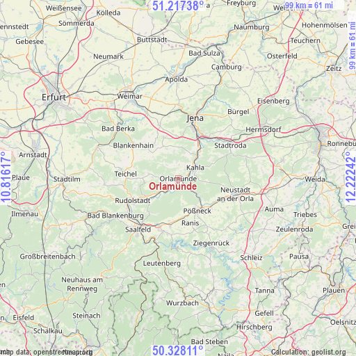
Orlamünde GPS coordinates[2]
50° 46' 29.496" North, 11° 31' 9.444" East
| Map corner | latitude | longitude |
|---|---|---|
| Upper-left | 51.21738°, | 10.81617° |
| Center: | 50.77486°, | 11.51929° |
| Lower-right: | 50.32811°, | 12.22242° |
| Map W x H: | 98.9×98.9 km | = 61.5×61.5mi |
| max Lat: | 55.01917° ⇑46.3% North |
| Orlamünde: | 50.77486° |
| min Lat: | ⇓53.7% South 47.40724° |
| min Long | Orlamünde | max Long |
| 5.92978° | 11.51929° | 14.98853° |
| W 74.6%⇐ | ⇒25.4% E |
Elevation
Elevation of Orlamünde is 251 m = 823 ft, and this is 1.9 m = 6 ft above average elevation for this country.
| Max E: |
1256 m = 4121 ft | 46.1% |
| Orlamünde | 251 m 823 ft | |
| Avg. | 249.1 m = 817 ft | |
Min E: |
-5 m = -16 ft | 53.9% |
See also: Germany elevation on elevation.city.
Geographical zone
Orlamünde is located in North temperate zone (between Tropic of Cancer and the Arctic Circle). Distance of this North polar circle is 1755.5 km =1090.8 mi to North.| Distance of | km | miles | from Orlamünde |
|---|---|---|---|
| North Pole | 4361.4 | 2710 | to North |
| Arctic Circle | 1755.5 | 1090.8 | to North |
| Tropic Cancer | 3039.7 | 1888.8 | to South |
| Equator | 5645.6 | 3508 | to South |


Nearby cities:
15 places around Orlamünde: (largest is in red/bold)
• Altenberga
6.6 km =4.1 mi,  8°
8°
• Bibra
3.8 km =2.4 mi,  31°
31°
• Eichenberg
3 km =1.9 mi,  19°
19°
• Freienorla
2.3 km =1.4 mi,  112°
112°
• Großeutersdorf
3.5 km =2.2 mi,  74°
74°
• Großpürschütz
7.3 km =4.5 mi,  50°
50°
• Gumperda
3.9 km =2.4 mi,  4°
4°
• Herschdorf
7.1 km =4.4 mi,  169°
169°
• Kahla
5.8 km =3.6 mi, 52°
• Kleineutersdorf
4.6 km =2.9 mi,  78°
78°
• Langenorla
5.7 km =3.5 mi,  131°
131°
• Lindig
5.8 km =3.6 mi, 80°
• Reinstädt
5 km =3.1 mi,  320°
320°
• Rückersdorf
5.1 km =3.2 mi,  216°
216°
• Seitenroda
7.4 km =4.6 mi, 67°
Sources, notices
• [Note1] Compared only with cities in Germany existing in our database
• [Src1] Map data: © OpenStreetMap contributors (CC-BY-SA)
• [Src2] Other city data from geonames.org with taken over terms of usage.
• [Src3] Geographical zone / Annual Mean Temperature by Robert A. Rohde @ Wikipedia
