Kirchehrenbach geodata
Kirchehrenbach (Bavaria) is a seat of a fourth-order administrative division; located in Germany in Europe/Berlin (GMT+2) time zone. With population of 2,304 people, there are 4663 cities with bigger population in this country. Compared to other cities in Germany, 70.6% of cities are located further ↑North; 69.1% of cities are located further ←West and 59.3% of cities have lower elevation than Kirchehrenbach. Note1
Administrative division(s):
- Level 1: Bavaria
- Level 2: Upper Franconia
- Level 3: Landkreis Forchheim
- Level 4: Kirchehrenbach


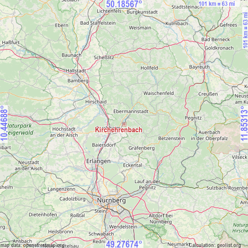
Kirchehrenbach GPS coordinates[2]
49° 43' 59.988" North, 11° 9' 0" East
| Map corner | latitude | longitude |
|---|---|---|
| Upper-left | 50.18567°, | 10.44688° |
| Center: | 49.73333°, | 11.15° |
| Lower-right: | 49.27674°, | 11.85313° |
| Map W x H: | 101.1×101.1 km | = 62.8×62.8mi |
| max Lat: | 55.01917° ⇑70.6% North |
| Kirchehrenbach: | 49.73333° |
| min Lat: | ⇓29.4% South 47.40724° |
| min Long | Kirchehrenbach | max Long |
| 5.92978° | 11.15° | 14.98853° |
| W 69.1%⇐ | ⇒30.9% E |
Elevation
Elevation of Kirchehrenbach is 285 m = 935 ft, and this is 35.9 m = 118 ft above average elevation for this country.
| Max E: |
1256 m = 4121 ft | 40.7% |
| Kirchehrenbach | 285 m 935 ft | |
| Avg. | 249.1 m = 817 ft | |
Min E: |
-5 m = -16 ft | 59.3% |
See also: Germany elevation on elevation.city.
Geographical zone
Kirchehrenbach is located in North temperate zone (between Tropic of Cancer and the Arctic Circle). Distance of this North polar circle is 1871.3 km =1162.8 mi to North.| Distance of | km | miles | from Kirchehrenbach |
|---|---|---|---|
| North Pole | 4477.2 | 2782 | to North |
| Arctic Circle | 1871.3 | 1162.8 | to North |
| Tropic Cancer | 2923.9 | 1816.8 | to South |
| Equator | 5529.8 | 3436.1 | to South |


Nearby cities:
15 places around Kirchehrenbach: (largest is in red/bold)
• Ebermannstadt
5.8 km =3.6 mi,  23°
23°
• Effeltrich
9.2 km =5.7 mi,  206°
206°
• Eggolsheim
7.8 km =4.8 mi,  301°
301°
• Egloffstein
8.5 km =5.3 mi,  114°
114°
• Forchheim
6.8 km =4.2 mi,  255°
255°
• Hausen
9.8 km =6.1 mi,  240°
240°
• Hetzles
11.2 km =7 mi,  186°
186°
• Kunreuth
5.7 km =3.5 mi,  184°
184°
• Leutenbach
3.1 km =1.9 mi,  148°
148°
• Pinzberg
5.9 km =3.7 mi,  215°
215°
• Poxdorf
9.6 km =6 mi, 216°
• Pretzfeld
2.9 km =1.8 mi,  36°
36°
• Unterleinleiter
10.4 km =6.5 mi, 15°
• Weilersbach
3 km =1.9 mi,  307°
307°
• Wiesenthau
2.5 km =1.6 mi,  204°
204°
Sources, notices
• [Note1] Compared only with cities in Germany existing in our database
• [Src1] Map data: © OpenStreetMap contributors (CC-BY-SA)
• [Src2] Other city data from geonames.org with taken over terms of usage.
• [Src3] Geographical zone / Annual Mean Temperature by Robert A. Rohde @ Wikipedia
