Kunreuth geodata
Kunreuth (Bavaria) is a seat of a fourth-order administrative division; located in Germany in Europe/Berlin (GMT+2) time zone. In our database, there are 11009 cities with bigger population. Compared to other cities in Germany, 71.9% of cities are located further ↑North; 69.1% of cities are located further ←West and 61.3% of cities have lower elevation than Kunreuth. Note1
Administrative division(s):
- Level 1: Bavaria
- Level 2: Upper Franconia
- Level 3: Landkreis Forchheim
- Level 4: Kunreuth


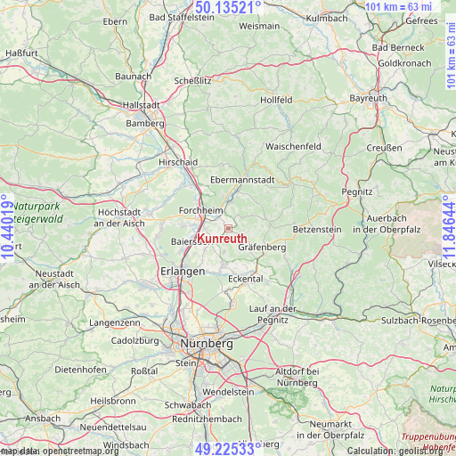
Kunreuth GPS coordinates[2]
49° 40' 56.64" North, 11° 8' 35.916" East
| Map corner | latitude | longitude |
|---|---|---|
| Upper-left | 50.13521°, | 10.44019° |
| Center: | 49.6824°, | 11.14331° |
| Lower-right: | 49.22533°, | 11.84644° |
| Map W x H: | 101.2×101.2 km | = 62.9×62.9mi |
| max Lat: | 55.01917° ⇑71.9% North |
| Kunreuth: | 49.6824° |
| min Lat: | ⇓28.1% South 47.40724° |
| min Long | Kunreuth | max Long |
| 5.92978° | 11.14331° | 14.98853° |
| W 69.1%⇐ | ⇒30.9% E |
Elevation
Elevation of Kunreuth is 298 m = 978 ft, and this is 48.9 m = 160 ft above average elevation for this country.
| Max E: |
1256 m = 4121 ft | 38.7% |
| Kunreuth | 298 m 978 ft | |
| Avg. | 249.1 m = 817 ft | |
Min E: |
-5 m = -16 ft | 61.3% |
See also: Germany elevation on elevation.city.
Geographical zone
Kunreuth is located in North temperate zone (between Tropic of Cancer and the Arctic Circle). Distance of this North polar circle is 1877 km =1166.3 mi to North.| Distance of | km | miles | from Kunreuth |
|---|---|---|---|
| North Pole | 4482.9 | 2785.5 | to North |
| Arctic Circle | 1877 | 1166.3 | to North |
| Tropic Cancer | 2918.2 | 1813.3 | to South |
| Equator | 5524.2 | 3432.6 | to South |


Nearby cities:
15 places around Kunreuth: (largest is in red/bold)
• Baiersdorf
8.2 km =5.1 mi,  250°
250°
• Effeltrich
4.4 km =2.7 mi,  234°
234°
• Egloffstein
8.5 km =5.3 mi,  75°
75°
• Forchheim
7.2 km =4.5 mi,  302°
302°
• Hausen
8 km =5 mi,  275°
275°
• Hetzles
5.5 km =3.4 mi,  187°
187°
• Kirchehrenbach
5.7 km =3.5 mi,  4°
4°
• Langensendelbach
7 km =4.3 mi, 228°
• Leutenbach
3.7 km =2.3 mi,  34°
34°
• Neunkirchen am Brand
7.9 km =4.9 mi, 187°
• Pinzberg
3.1 km =1.9 mi,  285°
285°
• Poxdorf
5.6 km =3.5 mi, 247°
• Pretzfeld
8.3 km =5.2 mi,  15°
15°
• Weilersbach
7.8 km =4.8 mi,  345°
345°
• Wiesenthau
3.5 km =2.2 mi, 350°
Sources, notices
• [Note1] Compared only with cities in Germany existing in our database
• [Src1] Map data: © OpenStreetMap contributors (CC-BY-SA)
• [Src2] Other city data from geonames.org with taken over terms of usage.
• [Src3] Geographical zone / Annual Mean Temperature by Robert A. Rohde @ Wikipedia
