Leutenbach geodata
Leutenbach (Bavaria) is a seat of a fourth-order administrative division; located in Germany in Europe/Berlin (GMT+2) time zone. With population of 1,775 people, there are 5388 cities with bigger population in this country. Compared to other cities in Germany, 71.2% of cities are located further ↑North; 69.5% of cities are located further ←West and 67.5% of cities have lower elevation than Leutenbach. Note1
Administrative division(s):
- Level 1: Bavaria
- Level 2: Upper Franconia
- Level 3: Landkreis Forchheim
- Level 4: Leutenbach


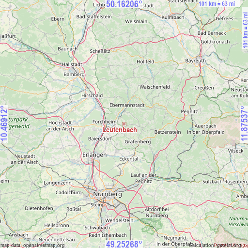
Leutenbach GPS coordinates[2]
49° 42' 34.2" North, 11° 10' 20.064" East
| Map corner | latitude | longitude |
|---|---|---|
| Upper-left | 50.16206°, | 10.46912° |
| Center: | 49.7095°, | 11.17224° |
| Lower-right: | 49.25268°, | 11.87537° |
| Map W x H: | 101.1×101.1 km | = 62.8×62.8mi |
| max Lat: | 55.01917° ⇑71.2% North |
| Leutenbach: | 49.7095° |
| min Lat: | ⇓28.8% South 47.40724° |
| min Long | Leutenbach | max Long |
| 5.92978° | 11.17224° | 14.98853° |
| W 69.5%⇐ | ⇒30.5% E |
Elevation
Elevation of Leutenbach is 339 m = 1112 ft, and this is 89.9 m = 295 ft above average elevation for this country.
| Max E: |
1256 m = 4121 ft | 32.5% |
| Leutenbach | 339 m 1112 ft | |
| Avg. | 249.1 m = 817 ft | |
Min E: |
-5 m = -16 ft | 67.5% |
See also: Germany elevation on elevation.city.
Geographical zone
Leutenbach is located in North temperate zone (between Tropic of Cancer and the Arctic Circle). Distance of this North polar circle is 1874 km =1164.4 mi to North.| Distance of | km | miles | from Leutenbach |
|---|---|---|---|
| North Pole | 4479.9 | 2783.7 | to North |
| Arctic Circle | 1874 | 1164.4 | to North |
| Tropic Cancer | 2921.3 | 1815.2 | to South |
| Equator | 5527.2 | 3434.4 | to South |


Nearby cities:
15 places around Leutenbach: (largest is in red/bold)
• Ebermannstadt
8 km =5 mi,  4°
4°
• Effeltrich
8 km =5 mi,  225°
225°
• Egloffstein
6.2 km =3.9 mi,  97°
97°
• Forchheim
8.2 km =5.1 mi,  276°
276°
• Gräfenberg
9.1 km =5.7 mi,  142°
142°
• Hausen
10.3 km =6.4 mi,  257°
257°
• Hetzles
8.9 km =5.5 mi,  198°
198°
• Kirchehrenbach
3.1 km =1.9 mi,  328°
328°
• Kunreuth
3.7 km =2.3 mi,  214°
214°
• Pinzberg
5.5 km =3.4 mi,  246°
246°
• Poxdorf
8.9 km =5.5 mi, 234°
• Pretzfeld
5 km =3.1 mi, 1°
• Weilersbach
6 km =3.7 mi,  318°
318°
• Weißenohe
10.5 km =6.5 mi,  146°
146°
• Wiesenthau
2.7 km =1.7 mi, 279°
Sources, notices
• [Note1] Compared only with cities in Germany existing in our database
• [Src1] Map data: © OpenStreetMap contributors (CC-BY-SA)
• [Src2] Other city data from geonames.org with taken over terms of usage.
• [Src3] Geographical zone / Annual Mean Temperature by Robert A. Rohde @ Wikipedia
