Karstädt geodata
Karstädt (Mecklenburg-Vorpommern) is a populated place; located in Germany in Europe/Berlin (GMT+2) time zone. With population of 657 people, there are 8526 cities with bigger population in this country. Compared to other cities in Germany, 83.6% of cities are located further ↓South; 74.1% of cities are located further ←West and 87% of cities have higher elevation than Karstädt. Note1
Administrative division(s):
- Level 1: Mecklenburg-Vorpommern
- Level 3: Ludwigslust-Parchim
- Level 4: Karstädt


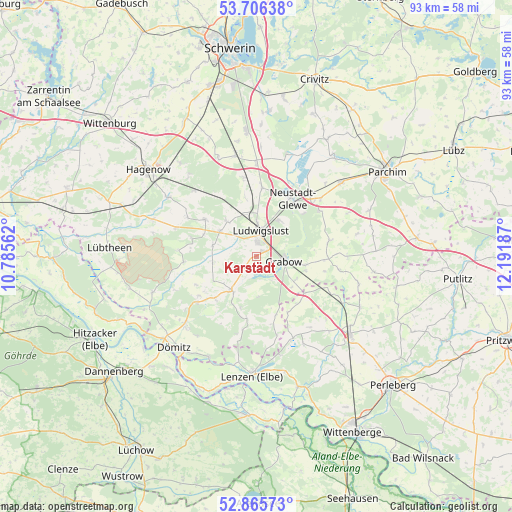
Karstädt GPS coordinates[2]
53° 17' 17.232" North, 11° 29' 19.464" East
| Map corner | latitude | longitude |
|---|---|---|
| Upper-left | 53.70638°, | 10.78562° |
| Center: | 53.28812°, | 11.48874° |
| Lower-right: | 52.86573°, | 12.19187° |
| Map W x H: | 93.5×93.5 km | = 58.1×58.1mi |
| max Lat: | 55.01917° ⇑16.4% North |
| Karstädt: | 53.28812° |
| min Lat: | ⇓83.6% South 47.40724° |
| min Long | Karstädt | max Long |
| 5.92978° | 11.48874° | 14.98853° |
| W 74.1%⇐ | ⇒25.9% E |
Elevation
Elevation of Karstädt is 30 m = 98 ft, and this is 219.1 m = 719 ft below average elevation for this country.
| Max E: |
1256 m = 4121 ft | 87% |
| Avg. | 249.1 m = 817 ft | |
| Karstädt | 30 m = 98 ft | |
Min E: |
-5 m = -16 ft | 13% |
See also: Germany elevation on elevation.city.
Geographical zone
Karstädt is located in North temperate zone (between Tropic of Cancer and the Arctic Circle). Distance of this North polar circle is 1476.1 km =917.2 mi to North.| Distance of | km | miles | from Karstädt |
|---|---|---|---|
| North Pole | 4082 | 2536.4 | to North |
| Arctic Circle | 1476.1 | 917.2 | to North |
| Tropic Cancer | 3319.2 | 2062.5 | to South |
| Equator | 5925.1 | 3681.7 | to South |


Nearby cities:
15 places around Karstädt: (largest is in red/bold)
• Alt Krenzlin
12.5 km =7.8 mi,  285°
285°
• Blievenstorf
14.3 km =8.9 mi,  55°
55°
• Brenz
15.8 km =9.8 mi,  47°
47°
• Eldena
7.8 km =4.8 mi,  216°
216°
• Grabow
5.2 km =3.2 mi,  100°
100°
• Groß Laasch
7.6 km =4.7 mi,  31°
31°
• Kummer
8.2 km =5.1 mi,  304°
304°
• Ludwigslust
4.6 km =2.9 mi,  6°
6°
• Lüblow
14.4 km =8.9 mi,  349°
349°
• Malliß
13.7 km =8.5 mi,  231°
231°
• Neustadt-Glewe
12.2 km =7.6 mi, 34°
• Picher
11.5 km =7.1 mi,  305°
305°
• Prislich
9 km =5.6 mi, 101°
• Warlow
8.4 km =5.2 mi,  318°
318°
• Wöbbelin
12.8 km =8 mi,  3°
3°
Sources, notices
• [Note1] Compared only with cities in Germany existing in our database
• [Src1] Map data: © OpenStreetMap contributors (CC-BY-SA)
• [Src2] Other city data from geonames.org with taken over terms of usage.
• [Src3] Geographical zone / Annual Mean Temperature by Robert A. Rohde @ Wikipedia
