Blievenstorf geodata
Blievenstorf (Mecklenburg-Vorpommern) is a populated place; located in Germany in Europe/Berlin (GMT+2) time zone. With population of 509 people, there are 9330 cities with bigger population in this country. Compared to other cities in Germany, 84.2% of cities are located further ↓South; 76.7% of cities are located further ←West and 81.4% of cities have higher elevation than Blievenstorf. Note1
Administrative division(s):
- Level 1: Mecklenburg-Vorpommern
- Level 3: Ludwigslust-Parchim
- Level 4: Blievenstorf


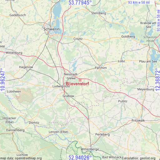
Blievenstorf GPS coordinates[2]
53° 21' 42.912" North, 11° 39' 56.124" East
| Map corner | latitude | longitude |
|---|---|---|
| Upper-left | 53.77945°, | 10.96247° |
| Center: | 53.36192°, | 11.66559° |
| Lower-right: | 52.94026°, | 12.36872° |
| Map W x H: | 93.3×93.3 km | = 58×58mi |
| max Lat: | 55.01917° ⇑15.8% North |
| Blievenstorf: | 53.36192° |
| min Lat: | ⇓84.2% South 47.40724° |
| min Long | Blievenstorf | max Long |
| 5.92978° | 11.66559° | 14.98853° |
| W 76.7%⇐ | ⇒23.3% E |
Elevation
Elevation of Blievenstorf is 43 m = 141 ft, and this is 206.1 m = 676 ft below average elevation for this country.
| Max E: |
1256 m = 4121 ft | 81.4% |
| Avg. | 249.1 m = 817 ft | |
| Blievenstorf | 43 m = 141 ft | |
Min E: |
-5 m = -16 ft | 18.6% |
See also: Germany elevation on elevation.city.
Geographical zone
Blievenstorf is located in North temperate zone (between Tropic of Cancer and the Arctic Circle). Distance of this North polar circle is 1467.9 km =912.1 mi to North.| Distance of | km | miles | from Blievenstorf |
|---|---|---|---|
| North Pole | 4073.8 | 2531.3 | to North |
| Arctic Circle | 1467.9 | 912.1 | to North |
| Tropic Cancer | 3327.4 | 2067.5 | to South |
| Equator | 5933.3 | 3686.8 | to South |


Nearby cities:
15 places around Blievenstorf: (largest is in red/bold)
• Brenz
2.4 km =1.5 mi,  0°
0°
• Damm
10.5 km =6.5 mi,  34°
34°
• Grabow
11.3 km =7 mi,  216°
216°
• Groß Laasch
7.9 km =4.9 mi,  257°
257°
• Karstädt
14.3 km =8.9 mi,  235°
235°
• Ludwigslust
11.8 km =7.3 mi,  251°
251°
• Löcknitz
11.3 km =7 mi,  137°
137°
• Matzlow-Garwitz
9.9 km =6.2 mi,  15°
15°
• Neustadt-Glewe
5.2 km =3.2 mi,  290°
290°
• Parchim
14.1 km =8.8 mi,  59°
59°
• Prislich
10.4 km =6.5 mi,  196°
196°
• Raduhn
13.3 km =8.3 mi,  5°
5°
• Spornitz
6.2 km =3.9 mi, 34°
• Wöbbelin
11.8 km =7.3 mi, 292°
• Ziegendorf
12.3 km =7.6 mi,  126°
126°
Sources, notices
• [Note1] Compared only with cities in Germany existing in our database
• [Src1] Map data: © OpenStreetMap contributors (CC-BY-SA)
• [Src2] Other city data from geonames.org with taken over terms of usage.
• [Src3] Geographical zone / Annual Mean Temperature by Robert A. Rohde @ Wikipedia
