Kappeln geodata
Kappeln (Schleswig-Holstein) is a populated place; located in Germany in Europe/Berlin (GMT+2) time zone. With population of 9,677 people, there are 1674 cities with bigger population in this country. Compared to other cities in Germany, 99% of cities are located further ↓South; 51.1% of cities are located further →East and 93.5% of cities have higher elevation than Kappeln. Note1
Administrative division(s):
- Level 1: Schleswig-Holstein
- Level 3: Kreis Schleswig-Flensburg
- Level 4: Kappeln


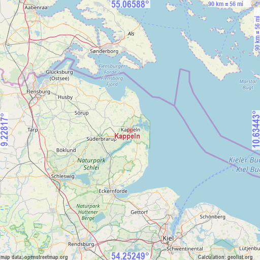
Kappeln GPS coordinates[2]
54° 39' 40.392" North, 9° 55' 52.68" East
| Map corner | latitude | longitude |
|---|---|---|
| Upper-left | 55.06588°, | 9.22817° |
| Center: | 54.66122°, | 9.9313° |
| Lower-right: | 54.25249°, | 10.63443° |
| Map W x H: | 90.4×90.4 km | = 56.2×56.2mi |
| max Lat: | 55.01917° ⇑1% North |
| Kappeln: | 54.66122° |
| min Lat: | ⇓99% South 47.40724° |
| min Long | Kappeln | max Long |
| 5.92978° | 9.9313° | 14.98853° |
| W 48.9%⇐ | ⇒51.1% E |
Elevation
Elevation of Kappeln is 12 m = 39 ft, and this is 237.1 m = 778 ft below average elevation for this country.
| Max E: |
1256 m = 4121 ft | 93.5% |
| Avg. | 249.1 m = 817 ft | |
| Kappeln | 12 m = 39 ft | |
Min E: |
-5 m = -16 ft | 6.5% |
See also: Germany elevation on elevation.city.
Geographical zone
Kappeln is located in North temperate zone (between Tropic of Cancer and the Arctic Circle). Distance of this North polar circle is 1323.4 km =822.3 mi to North.| Distance of | km | miles | from Kappeln |
|---|---|---|---|
| North Pole | 3929.3 | 2441.6 | to North |
| Arctic Circle | 1323.4 | 822.3 | to North |
| Tropic Cancer | 3471.8 | 2157.3 | to South |
| Equator | 6077.8 | 3776.6 | to South |


Nearby cities:
15 places around Kappeln: (largest is in red/bold)
• Brodersby
4.6 km =2.9 mi,  132°
132°
• Dollrottfeld
8 km =5 mi,  247°
247°
• Dörphof
5.5 km =3.4 mi,  155°
155°
• Grödersby
3.2 km =2 mi,  196°
196°
• Hasselberg
7 km =4.3 mi,  28°
28°
• Karby
5 km =3.1 mi,  147°
147°
• Maasholm
4.2 km =2.6 mi,  53°
53°
• Oersberg
5.3 km =3.3 mi,  276°
276°
• Rabel
4.5 km =2.8 mi,  15°
15°
• Rabenholz
6.5 km =4 mi,  341°
341°
• Rabenkirchen-Faulück
6.1 km =3.8 mi,  239°
239°
• Scheggerott
7.4 km =4.6 mi,  274°
274°
• Stangheck
7.4 km =4.6 mi,  326°
326°
• Stoltebüll
5.3 km =3.3 mi,  324°
324°
• Winnemark
5 km =3.1 mi,  190°
190°
Sources, notices
• [Note1] Compared only with cities in Germany existing in our database
• [Src1] Map data: © OpenStreetMap contributors (CC-BY-SA)
• [Src2] Other city data from geonames.org with taken over terms of usage.
• [Src3] Geographical zone / Annual Mean Temperature by Robert A. Rohde @ Wikipedia
