Itterbeck geodata
Itterbeck (Lower Saxony) is a seat of a fourth-order administrative division; located in Germany in Europe/Berlin (GMT+2) time zone. With population of 1,821 people, there are 5313 cities with bigger population in this country. Compared to other cities in Germany, 77.5% of cities are located further ↓South; 95.5% of cities are located further →East and 82.8% of cities have higher elevation than Itterbeck. Note1
Administrative division(s):
- Level 1: Lower Saxony
- Level 3: Landkreis Grafschaft Bentheim
- Level 4: Itterbeck


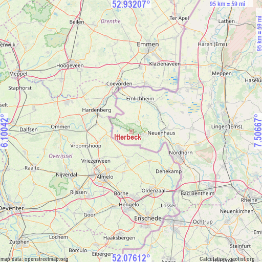
Itterbeck GPS coordinates[2]
52° 30' 22.248" North, 6° 48' 12.744" East
| Map corner | latitude | longitude |
|---|---|---|
| Upper-left | 52.93207°, | 6.10042° |
| Center: | 52.50618°, | 6.80354° |
| Lower-right: | 52.07612°, | 7.50667° |
| Map W x H: | 95.2×95.2 km | = 59.2×59.2mi |
| max Lat: | 55.01917° ⇑22.5% North |
| Itterbeck: | 52.50618° |
| min Lat: | ⇓77.5% South 47.40724° |
| min Long | Itterbeck | max Long |
| 5.92978° | 6.80354° | 14.98853° |
| W 4.5%⇐ | ⇒95.5% E |
Elevation
Elevation of Itterbeck is 40 m = 131 ft, and this is 209.1 m = 686 ft below average elevation for this country.
| Max E: |
1256 m = 4121 ft | 82.8% |
| Avg. | 249.1 m = 817 ft | |
| Itterbeck | 40 m = 131 ft | |
Min E: |
-5 m = -16 ft | 17.2% |
See also: Germany elevation on elevation.city.
Geographical zone
Itterbeck is located in North temperate zone (between Tropic of Cancer and the Arctic Circle). Distance of this North polar circle is 1563 km =971.2 mi to North.| Distance of | km | miles | from Itterbeck |
|---|---|---|---|
| North Pole | 4168.9 | 2590.4 | to North |
| Arctic Circle | 1563 | 971.2 | to North |
| Tropic Cancer | 3232.2 | 2008.4 | to South |
| Equator | 5838.1 | 3627.6 | to South |


Nearby cities:
15 places around Itterbeck: (largest is in red/bold)
• Emlichheim
12.7 km =7.9 mi,  14°
14°
• Engden
28.3 km =17.6 mi,  114°
114°
• Esche
11.4 km =7.1 mi,  74°
74°
• Georgsdorf
20.1 km =12.5 mi, 70°
• Getelo
5.4 km =3.4 mi,  144°
144°
• Gölenkamp
7.7 km =4.8 mi,  81°
81°
• Hoogstede
13.1 km =8.1 mi,  49°
49°
• Laar
13.2 km =8.2 mi,  338°
338°
• Lohne
28.6 km =17.8 mi,  91°
91°
• Nordhorn
19.8 km =12.3 mi,  115°
115°
• Twist
23 km =14.3 mi, 50°
• Uelsen
5.4 km =3.4 mi,  97°
97°
• Wielen
7.6 km =4.7 mi,  309°
309°
• Wietmarschen
22.4 km =13.9 mi, 86°
• Wilsum
4.4 km =2.7 mi, 46°
Sources, notices
• [Note1] Compared only with cities in Germany existing in our database
• [Src1] Map data: © OpenStreetMap contributors (CC-BY-SA)
• [Src2] Other city data from geonames.org with taken over terms of usage.
• [Src3] Geographical zone / Annual Mean Temperature by Robert A. Rohde @ Wikipedia
