Isselbach geodata
Isselbach (Rheinland-Pfalz) is a seat of a fourth-order administrative division; located in Germany in Europe/Berlin (GMT+2) time zone. With population of 402 people, there are 9686 cities with bigger population in this country. Compared to other cities in Germany, 54.7% of cities are located further ↑North; 79% of cities are located further →East and 55% of cities have lower elevation than Isselbach. Note1


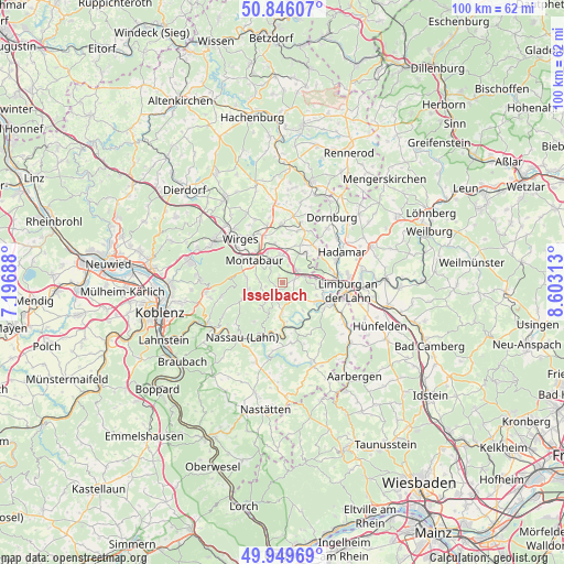
Isselbach GPS coordinates[2]
50° 24' 0" North, 7° 54' 0" East
| Map corner | latitude | longitude |
|---|---|---|
| Upper-left | 50.84607°, | 7.19688° |
| Center: | 50.4°, | 7.9° |
| Lower-right: | 49.94969°, | 8.60313° |
| Map W x H: | 99.7×99.7 km | = 62×62mi |
| max Lat: | 55.01917° ⇑54.7% North |
| Isselbach: | 50.4° |
| min Lat: | ⇓45.3% South 47.40724° |
| min Long | Isselbach | max Long |
| 5.92978° | 7.9° | 14.98853° |
| W 21%⇐ | ⇒79% E |
Elevation
Elevation of Isselbach is 258 m = 846 ft, and this is 8.9 m = 29 ft above average elevation for this country.
| Max E: |
1256 m = 4121 ft | 45% |
| Isselbach | 258 m 846 ft | |
| Avg. | 249.1 m = 817 ft | |
Min E: |
-5 m = -16 ft | 55% |
See also: Germany elevation on elevation.city.
Geographical zone
Isselbach is located in North temperate zone (between Tropic of Cancer and the Arctic Circle). Distance of this North polar circle is 1797.2 km =1116.7 mi to North.| Distance of | km | miles | from Isselbach |
|---|---|---|---|
| North Pole | 4403.1 | 2736 | to North |
| Arctic Circle | 1797.2 | 1116.7 | to North |
| Tropic Cancer | 2998 | 1862.9 | to South |
| Equator | 5604 | 3482.2 | to South |


Nearby cities:
15 places around Isselbach: (largest is in red/bold)
• Daubach
3.5 km =2.2 mi,  270°
270°
• Dreikirchen
5.1 km =3.2 mi,  43°
43°
• Eppenrod
2.2 km =1.4 mi,  76°
76°
• Gackenbach
4.4 km =2.7 mi,  212°
212°
• Görgeshausen
4 km =2.5 mi,  62°
62°
• Heilberscheid
2.2 km =1.4 mi,  327°
327°
• Hirschberg
2.9 km =1.8 mi,  143°
143°
• Holler
5.1 km =3.2 mi,  291°
291°
• Holzappel
5.6 km =3.5 mi,  180°
180°
• Horbach
4.5 km =2.8 mi,  228°
228°
• Horhausen
3.7 km =2.3 mi, 180°
• Nentershausen
3 km =1.9 mi,  51°
51°
• Nomborn
3.9 km =2.4 mi,  17°
17°
• Stahlhofen
3 km =1.9 mi,  256°
256°
• Untershausen
3.5 km =2.2 mi, 270°
Sources, notices
• [Note1] Compared only with cities in Germany existing in our database
• [Src1] Map data: © OpenStreetMap contributors (CC-BY-SA)
• [Src2] Other city data from geonames.org with taken over terms of usage.
• [Src3] Geographical zone / Annual Mean Temperature by Robert A. Rohde @ Wikipedia
