Holler geodata
Holler (Rheinland-Pfalz) is a seat of a fourth-order administrative division; located in Germany in Europe/Berlin (GMT+2) time zone. With population of 1,191 people, there are 6589 cities with bigger population in this country. Compared to other cities in Germany, 54.4% of cities are located further ↑North; 80.4% of cities are located further →East and 50.4% of cities have higher elevation than Holler. Note1


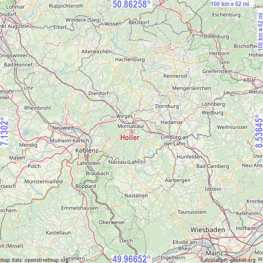
Holler GPS coordinates[2]
50° 25' 0.012" North, 7° 49' 59.988" East
| Map corner | latitude | longitude |
|---|---|---|
| Upper-left | 50.86258°, | 7.1302° |
| Center: | 50.41667°, | 7.83333° |
| Lower-right: | 49.96652°, | 8.53645° |
| Map W x H: | 99.6×99.6 km | = 61.9×61.9mi |
| max Lat: | 55.01917° ⇑54.4% North |
| Holler: | 50.41667° |
| min Lat: | ⇓45.6% South 47.40724° |
| min Long | Holler | max Long |
| 5.92978° | 7.83333° | 14.98853° |
| W 19.6%⇐ | ⇒80.4% E |
Elevation
Elevation of Holler is 222 m = 728 ft, and this is 27.1 m = 89 ft below average elevation for this country.
| Max E: |
1256 m = 4121 ft | 50.4% |
| Avg. | 249.1 m = 817 ft | |
| Holler | 222 m = 728 ft | |
Min E: |
-5 m = -16 ft | 49.6% |
See also: Germany elevation on elevation.city.
Geographical zone
Holler is located in North temperate zone (between Tropic of Cancer and the Arctic Circle). Distance of this North polar circle is 1795.4 km =1115.6 mi to North.| Distance of | km | miles | from Holler |
|---|---|---|---|
| North Pole | 4401.3 | 2734.8 | to North |
| Arctic Circle | 1795.4 | 1115.6 | to North |
| Tropic Cancer | 2999.9 | 1864.1 | to South |
| Equator | 5605.8 | 3483.3 | to South |


Nearby cities:
15 places around Holler: (largest is in red/bold)
• Daubach
2.2 km =1.4 mi,  147°
147°
• Dernbach
5.3 km =3.3 mi,  324°
324°
• Gackenbach
6 km =3.7 mi,  156°
156°
• Großholbach
5.1 km =3.2 mi,  43°
43°
• Heilberscheid
3.5 km =2.2 mi,  90°
90°
• Heiligenroth
4.4 km =2.7 mi,  32°
32°
• Horbach
5 km =3.1 mi, 164°
• Isselbach
5.1 km =3.2 mi,  111°
111°
• Montabaur
2.3 km =1.4 mi,  341°
341°
• Niederelbert
1.9 km =1.2 mi,  239°
239°
• Oberelbert
3 km =1.9 mi,  202°
202°
• Stahlhofen
3.1 km =1.9 mi,  143°
143°
• Staudt
5.6 km =3.5 mi,  0°
0°
• Untershausen
2.2 km =1.4 mi, 147°
• Welschneudorf
5.4 km =3.4 mi,  207°
207°
Sources, notices
• [Note1] Compared only with cities in Germany existing in our database
• [Src1] Map data: © OpenStreetMap contributors (CC-BY-SA)
• [Src2] Other city data from geonames.org with taken over terms of usage.
• [Src3] Geographical zone / Annual Mean Temperature by Robert A. Rohde @ Wikipedia
