Nomborn geodata
Nomborn (Rheinland-Pfalz) is a seat of a fourth-order administrative division; located in Germany in Europe/Berlin (GMT+2) time zone. With population of 715 people, there are 8253 cities with bigger population in this country. Compared to other cities in Germany, 54% of cities are located further ↑North; 78.7% of cities are located further →East and 58.7% of cities have lower elevation than Nomborn. Note1


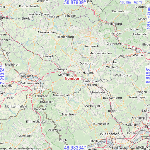
Nomborn GPS coordinates[2]
50° 25' 59.988" North, 7° 55' 0.012" East
| Map corner | latitude | longitude |
|---|---|---|
| Upper-left | 50.87909°, | 7.21355° |
| Center: | 50.43333°, | 7.91667° |
| Lower-right: | 49.98334°, | 8.6198° |
| Map W x H: | 99.6×99.6 km | = 61.9×61.9mi |
| max Lat: | 55.01917° ⇑54% North |
| Nomborn: | 50.43333° |
| min Lat: | ⇓46% South 47.40724° |
| min Long | Nomborn | max Long |
| 5.92978° | 7.91667° | 14.98853° |
| W 21.3%⇐ | ⇒78.7% E |
Elevation
Elevation of Nomborn is 282 m = 925 ft, and this is 32.9 m = 108 ft above average elevation for this country.
| Max E: |
1256 m = 4121 ft | 41.3% |
| Nomborn | 282 m 925 ft | |
| Avg. | 249.1 m = 817 ft | |
Min E: |
-5 m = -16 ft | 58.7% |
See also: Germany elevation on elevation.city.
Geographical zone
Nomborn is located in North temperate zone (between Tropic of Cancer and the Arctic Circle). Distance of this North polar circle is 1793.5 km =1114.4 mi to North.| Distance of | km | miles | from Nomborn |
|---|---|---|---|
| North Pole | 4399.4 | 2733.7 | to North |
| Arctic Circle | 1793.5 | 1114.4 | to North |
| Tropic Cancer | 3001.7 | 1865.2 | to South |
| Equator | 5607.7 | 3484.5 | to South |


Nearby cities:
15 places around Nomborn: (largest is in red/bold)
• Dreikirchen
2.4 km =1.5 mi,  90°
90°
• Eppenrod
3.3 km =2.1 mi,  163°
163°
• Girod
1.9 km =1.2 mi,  0°
0°
• Großholbach
3 km =1.9 mi,  308°
308°
• Görgeshausen
3 km =1.9 mi,  128°
128°
• Heilberscheid
3 km =1.9 mi,  231°
231°
• Heiligenroth
4 km =2.5 mi,  297°
297°
• Isselbach
3.9 km =2.4 mi,  197°
197°
• Nentershausen
2.2 km =1.4 mi,  147°
147°
• Niedererbach
4.2 km =2.6 mi,  101°
101°
• Obererbach
4 km =2.5 mi,  62°
62°
• Ruppach-Goldhausen
4.4 km =2.7 mi,  327°
327°
• Steinefrenz
3.1 km =1.9 mi,  21°
21°
• Weroth
3.8 km =2.4 mi,  36°
36°
• Zehnhausen bei Wallmerod
4.8 km =3 mi,  5°
5°
Sources, notices
• [Note1] Compared only with cities in Germany existing in our database
• [Src1] Map data: © OpenStreetMap contributors (CC-BY-SA)
• [Src2] Other city data from geonames.org with taken over terms of usage.
• [Src3] Geographical zone / Annual Mean Temperature by Robert A. Rohde @ Wikipedia
