Irrhausen geodata
Irrhausen (Rheinland-Pfalz) is a seat of a fourth-order administrative division; located in Germany in Europe/Berlin (GMT+2) time zone. With population of 239 people, there are 10309 cities with bigger population in this country. Compared to other cities in Germany, 62.2% of cities are located further ↑North; 99.7% of cities are located further →East and 70.4% of cities have lower elevation than Irrhausen. Note1
Administrative division(s):
- Level 1: Rheinland-Pfalz
- Level 3: Eifelkreis Bitburg-Prüm
- Level 4: Irrhausen


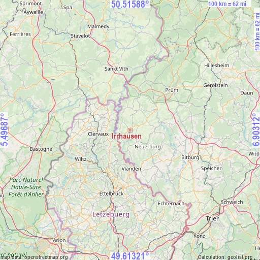
Irrhausen GPS coordinates[2]
50° 4' 0.012" North, 6° 12' 0" East
| Map corner | latitude | longitude |
|---|---|---|
| Upper-left | 50.51588°, | 5.49687° |
| Center: | 50.06667°, | 6.2° |
| Lower-right: | 49.61321°, | 6.90312° |
| Map W x H: | 100.4×100.4 km | = 62.4×62.4mi |
| max Lat: | 55.01917° ⇑62.2% North |
| Irrhausen: | 50.06667° |
| min Lat: | ⇓37.8% South 47.40724° |
| min Long | Irrhausen | max Long |
| 5.92978° | 6.2° | 14.98853° |
| W 0.3%⇐ | ⇒99.7% E |
Elevation
Elevation of Irrhausen is 361 m = 1184 ft, and this is 111.9 m = 367 ft above average elevation for this country.
| Max E: |
1256 m = 4121 ft | 29.6% |
| Irrhausen | 361 m 1184 ft | |
| Avg. | 249.1 m = 817 ft | |
Min E: |
-5 m = -16 ft | 70.4% |
See also: Germany elevation on elevation.city.
Geographical zone
Irrhausen is located in North temperate zone (between Tropic of Cancer and the Arctic Circle). Distance of this North polar circle is 1834.3 km =1139.8 mi to North.| Distance of | km | miles | from Irrhausen |
|---|---|---|---|
| North Pole | 4440.2 | 2759 | to North |
| Arctic Circle | 1834.3 | 1139.8 | to North |
| Tropic Cancer | 2961 | 1839.9 | to South |
| Equator | 5566.9 | 3459.1 | to South |


Nearby cities:
15 places around Irrhausen: (largest is in red/bold)
• Dahnen
3.6 km =2.2 mi,  270°
270°
• Daleiden
1.2 km =0.7 mi,  287°
287°
• Dasburg
5.1 km =3.2 mi,  248°
248°
• Emmelbaum
5.1 km =3.2 mi,  111°
111°
• Eschfeld
5.6 km =3.5 mi,  0°
0°
• Jucken
3 km =1.9 mi,  127°
127°
• Karlshausen
5.2 km =3.2 mi,  157°
157°
• Kickeshausen
3.6 km =2.2 mi,  90°
90°
• Olmscheid
1.2 km =0.7 mi, 90°
• Preischeid
5.1 km =3.2 mi,  223°
223°
• Reiff
3.7 km =2.3 mi, 0°
• Reipeldingen
2.2 km =1.4 mi,  327°
327°
• Scheitenkorb
5.6 km =3.5 mi,  180°
180°
• Sengerich
5.7 km =3.5 mi,  12°
12°
• Zweifelscheid
5.1 km =3.2 mi,  136°
136°
Sources, notices
• [Note1] Compared only with cities in Germany existing in our database
• [Src1] Map data: © OpenStreetMap contributors (CC-BY-SA)
• [Src2] Other city data from geonames.org with taken over terms of usage.
• [Src3] Geographical zone / Annual Mean Temperature by Robert A. Rohde @ Wikipedia
