Daleiden geodata
Daleiden (Rheinland-Pfalz) is a seat of a fourth-order administrative division; located in Germany in Europe/Berlin (GMT+2) time zone. With population of 885 people, there are 7575 cities with bigger population in this country. Compared to other cities in Germany, 61.9% of cities are located further ↑North; 99.8% of cities are located further →East and 85.6% of cities have lower elevation than Daleiden. Note1
Administrative division(s):
- Level 1: Rheinland-Pfalz
- Level 3: Eifelkreis Bitburg-Prüm
- Level 4: Daleiden


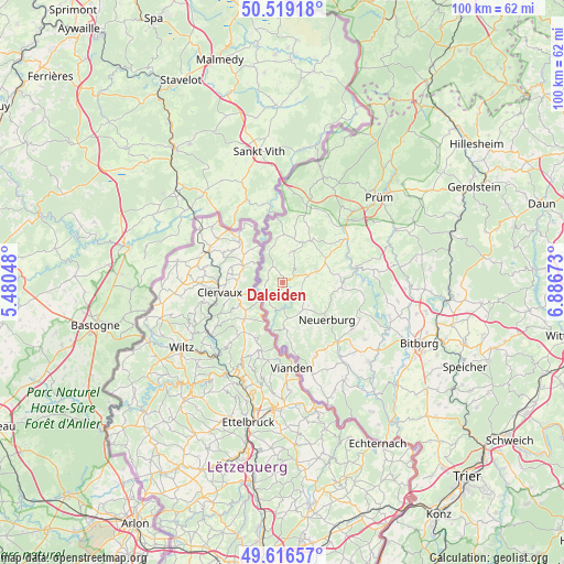
Daleiden GPS coordinates[2]
50° 4' 12" North, 6° 11' 0.996" East
| Map corner | latitude | longitude |
|---|---|---|
| Upper-left | 50.51918°, | 5.48048° |
| Center: | 50.07°, | 6.18361° |
| Lower-right: | 49.61657°, | 6.88673° |
| Map W x H: | 100.4×100.4 km | = 62.4×62.4mi |
| max Lat: | 55.01917° ⇑61.9% North |
| Daleiden: | 50.07° |
| min Lat: | ⇓38.1% South 47.40724° |
| min Long | Daleiden | max Long |
| 5.92978° | 6.18361° | 14.98853° |
| W 0.2%⇐ | ⇒99.8% E |
Elevation
Elevation of Daleiden is 474 m = 1555 ft, and this is 224.9 m = 738 ft above average elevation for this country.
| Max E: |
1256 m = 4121 ft | 14.4% |
| Daleiden | 474 m 1555 ft | |
| Avg. | 249.1 m = 817 ft | |
Min E: |
-5 m = -16 ft | 85.6% |
See also: Germany elevation on elevation.city.
Geographical zone
Daleiden is located in North temperate zone (between Tropic of Cancer and the Arctic Circle). Distance of this North polar circle is 1833.9 km =1139.5 mi to North.| Distance of | km | miles | from Daleiden |
|---|---|---|---|
| North Pole | 4439.8 | 2758.8 | to North |
| Arctic Circle | 1833.9 | 1139.5 | to North |
| Tropic Cancer | 2961.3 | 1840.1 | to South |
| Equator | 5567.3 | 3459.4 | to South |


Nearby cities:
15 places around Daleiden: (largest is in red/bold)
• Dahnen
2.4 km =1.5 mi,  261°
261°
• Dasburg
4.2 km =2.6 mi,  238°
238°
• Emmelbaum
6.3 km =3.9 mi,  110°
110°
• Eschfeld
5.3 km =3.3 mi,  12°
12°
• Irrhausen
1.2 km =0.7 mi, 107°
• Jucken
4.2 km =2.6 mi,  122°
122°
• Karlshausen
6 km =3.7 mi,  148°
148°
• Kickeshausen
4.8 km =3 mi,  94°
94°
• Olmscheid
2.4 km =1.5 mi,  98°
98°
• Preischeid
4.7 km =2.9 mi,  210°
210°
• Reiff
3.5 km =2.2 mi,  19°
19°
• Reipeldingen
1.5 km =0.9 mi,  359°
359°
• Roscheid
5.2 km =3.2 mi, 359°
• Scheitenkorb
6 km =3.7 mi,  168°
168°
• Sengerich
5.7 km =3.5 mi, 24°
Sources, notices
• [Note1] Compared only with cities in Germany existing in our database
• [Src1] Map data: © OpenStreetMap contributors (CC-BY-SA)
• [Src2] Other city data from geonames.org with taken over terms of usage.
• [Src3] Geographical zone / Annual Mean Temperature by Robert A. Rohde @ Wikipedia
